Estrées geodata
Estrées (Hauts-de-France) is a populated place; located in France in Europe/Paris (GMT+2) time zone. With population of 1,047 people, there are 8486 cities with bigger population in this country. Compared to other cities in France, 95.6% of cities are located further ↓South; 58.8% of cities are located further ←West and 80.2% of cities have higher elevation than Estrées. Note1
Administrative division(s):
- Level 1: Hauts-de-France
- Level 2: Nord
- Level 3: Arrondissement de Douai
- Level 4: Estrées


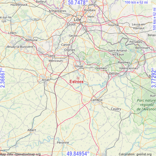
Estrées GPS coordinates[2]
50° 18' 2.844" North, 3° 4' 11.28" East
| Map corner | latitude | longitude |
|---|---|---|
| Upper-left | 50.7478°, | 2.36667° |
| Center: | 50.30079°, | 3.0698° |
| Lower-right: | 49.84954°, | 3.77292° |
| Map W x H: | 99.9×99.9 km | = 62.1×62.1mi |
| max Lat: | 51.07786° ⇑4.4% North |
| Estrées: | 50.30079° |
| min Lat: | ⇓95.6% South 41.3874° |
| min Long | Estrées | max Long |
| -5.08615° | 3.0698° | 9.52242° |
| W 58.8%⇐ | ⇒41.2% E |
Elevation
Elevation of Estrées is 54 m = 177 ft, and this is 139.7 m = 458 ft below average elevation for this country.
| Max E: |
2333 m = 7654 ft | 80.2% |
| Avg. | 193.7 m = 635 ft | |
| Estrées | 54 m = 177 ft | |
Min E: |
-1 m = -3 ft | 19.8% |
See also: France elevation on elevation.city.
Geographical zone
Estrées is located in North temperate zone (between Tropic of Cancer and the Arctic Circle). Distance of this North polar circle is 1808.3 km =1123.6 mi to North.| Distance of | km | miles | from Estrées |
|---|---|---|---|
| North Pole | 4414.1 | 2742.8 | to North |
| Arctic Circle | 1808.3 | 1123.6 | to North |
| Tropic Cancer | 2987 | 1856 | to South |
| Equator | 5592.9 | 3475.3 | to South |


Nearby cities:
15 places around Estrées: (largest is in red/bold)
• Arleux
3.4 km =2.1 mi,  132°
132°
• Brebières
5.2 km =3.2 mi,  313°
313°
• Cantin
4.2 km =2.6 mi,  77°
77°
• Corbehem
3.7 km =2.3 mi,  337°
337°
• Courchelettes
4.5 km =2.8 mi,  350°
350°
• Férin
3 km =1.9 mi,  5°
5°
• Gouy-sous-Bellonne
1.5 km =0.9 mi,  321°
321°
• Gœulzin
2.8 km =1.7 mi,  50°
50°
• Hamel
2.4 km =1.5 mi,  172°
172°
• Lambres-lez-Douai
5.5 km =3.4 mi,  357°
357°
• Lécluse
3.4 km =2.1 mi,  217°
217°
• Noyelles-sous-Bellonne
3.1 km =1.9 mi,  285°
285°
• Palluel
4.7 km =2.9 mi,  159°
159°
• Tortequesne
2.5 km =1.6 mi,  238°
238°
• Écourt-Saint-Quentin
5.4 km =3.4 mi,  177°
177°
Sources, notices
• [Note1] Compared only with cities in France existing in our database
• [Src1] Map data: © OpenStreetMap contributors (CC-BY-SA)
• [Src2] Other city data from geonames.org with taken over terms of usage.
• [Src3] Geographical zone / Annual Mean Temperature by Robert A. Rohde @ Wikipedia
