Le Barp geodata
Le Barp (Nouvelle-Aquitaine) is a populated place; located in France in Europe/Paris (GMT+2) time zone. With population of 4,230 people, there are 2327 cities with bigger population in this country. Compared to other cities in France, 82.7% of cities are located further ↑North; 86.2% of cities are located further →East and 72.3% of cities have higher elevation than Le Barp. Note1
Administrative division(s):
- Level 1: Nouvelle-Aquitaine
- Level 2: Gironde
- Level 3: Arrondissement d'Arcachon
- Level 4: Le Barp


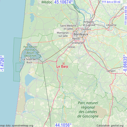
Le Barp GPS coordinates[2]
44° 36' 29.988" North, 0° 46' 10.128" West
| Map corner | latitude | longitude |
|---|---|---|
| Upper-left | 45.10674°, | -1.4726° |
| Center: | 44.60833°, | -0.76948° |
| Lower-right: | 44.1056°, | -0.06635° |
| Map W x H: | 111.3×111.3 km | = 69.2×69.2mi |
| max Lat: | 51.07786° ⇑82.7% North |
| Le Barp: | 44.60833° |
| min Lat: | ⇓17.3% South 41.3874° |
| min Long | Le Barp | max Long |
| -5.08615° | -0.76948° | 9.52242° |
| W 13.8%⇐ | ⇒86.2% E |
Elevation
Elevation of Le Barp is 73 m = 240 ft, and this is 120.7 m = 396 ft below average elevation for this country.
| Max E: |
2333 m = 7654 ft | 72.3% |
| Avg. | 193.7 m = 635 ft | |
| Le Barp | 73 m = 240 ft | |
Min E: |
-1 m = -3 ft | 27.7% |
See also: France elevation on elevation.city.
Geographical zone
Le Barp is located in North temperate zone (between Tropic of Cancer and the Arctic Circle). Distance of this Northern Tropic circle is 2354.1 km =1462.8 mi to South.| Distance of | km | miles | from Le Barp |
|---|---|---|---|
| North Pole | 5047.1 | 3136.1 | to North |
| Arctic Circle | 2441.2 | 1516.9 | to North |
| Tropic Cancer | 2354.1 | 1462.8 | to South |
| Equator | 4960 | 3082 | to South |


Nearby cities:
15 places around Le Barp: (largest is in red/bold)
• Belin-Béliet
12.1 km =7.5 mi,  185°
185°
• Biganos
16.7 km =10.4 mi,  284°
284°
• Cabanac-et-Villagrains
17.4 km =10.8 mi,  93°
93°
• Canéjan
20.6 km =12.8 mi,  31°
31°
• Cestas
16.6 km =10.3 mi, 25°
• Hostens
16.4 km =10.2 mi,  141°
141°
• Le Teich
20.1 km =12.5 mi, 277°
• Louchats
19.2 km =11.9 mi,  123°
123°
• Lugos
16.7 km =10.4 mi,  212°
212°
• Léognan
19.6 km =12.2 mi,  43°
43°
• Marcheprime
11.5 km =7.1 mi,  323°
323°
• Mios
13 km =8.1 mi,  268°
268°
• Saint-Magne
12.6 km =7.8 mi, 136°
• Salles
9.7 km =6 mi,  228°
228°
• Saucats
14.6 km =9.1 mi,  69°
69°
Sources, notices
• [Note1] Compared only with cities in France existing in our database
• [Src1] Map data: © OpenStreetMap contributors (CC-BY-SA)
• [Src2] Other city data from geonames.org with taken over terms of usage.
• [Src3] Geographical zone / Annual Mean Temperature by Robert A. Rohde @ Wikipedia
