Hostens geodata
Hostens (Nouvelle-Aquitaine) is a populated place; located in France in Europe/Paris (GMT+2) time zone. With population of 809 people, there are 10494 cities with bigger population in this country. Compared to other cities in France, 83.6% of cities are located further ↑North; 84.9% of cities are located further →East and 70.5% of cities have higher elevation than Hostens. Note1
Administrative division(s):
- Level 1: Nouvelle-Aquitaine
- Level 2: Gironde
- Level 3: Arrondissement de Langon
- Level 4: Hostens


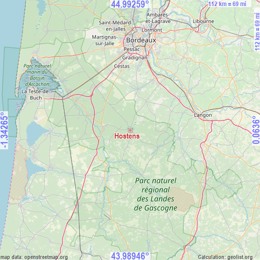
Hostens GPS coordinates[2]
44° 29' 35.448" North, 0° 38' 22.272" West
| Map corner | latitude | longitude |
|---|---|---|
| Upper-left | 44.99259°, | -1.34265° |
| Center: | 44.49318°, | -0.63952° |
| Lower-right: | 43.98946°, | 0.0636° |
| Map W x H: | 111.5×111.5 km | = 69.3×69.3mi |
| max Lat: | 51.07786° ⇑83.6% North |
| Hostens: | 44.49318° |
| min Lat: | ⇓16.4% South 41.3874° |
| min Long | Hostens | max Long |
| -5.08615° | -0.63952° | 9.52242° |
| W 15.1%⇐ | ⇒84.9% E |
Elevation
Elevation of Hostens is 77 m = 253 ft, and this is 116.7 m = 383 ft below average elevation for this country.
| Max E: |
2333 m = 7654 ft | 70.5% |
| Avg. | 193.7 m = 635 ft | |
| Hostens | 77 m = 253 ft | |
Min E: |
-1 m = -3 ft | 29.5% |
See also: France elevation on elevation.city.
Geographical zone
Hostens is located in North temperate zone (between Tropic of Cancer and the Arctic Circle). Distance of this Northern Tropic circle is 2341.3 km =1454.8 mi to South.| Distance of | km | miles | from Hostens |
|---|---|---|---|
| North Pole | 5059.9 | 3144.1 | to North |
| Arctic Circle | 2454 | 1524.8 | to North |
| Tropic Cancer | 2341.3 | 1454.8 | to South |
| Equator | 4947.2 | 3074 | to South |


Nearby cities:
15 places around Hostens: (largest is in red/bold)
• Belin-Béliet
11.4 km =7.1 mi,  273°
273°
• Budos
20.5 km =12.7 mi,  77°
77°
• Cabanac-et-Villagrains
13.8 km =8.6 mi,  30°
30°
• Landiras
19.6 km =12.2 mi,  65°
65°
• Le Barp
16.4 km =10.2 mi,  321°
321°
• Louchats
6.2 km =3.9 mi, 69°
• Lugos
19.4 km =12.1 mi, 266°
• Moustey
17.8 km =11.1 mi,  212°
212°
• Saint-Magne
4 km =2.5 mi,  337°
337°
• Saint-Morillon
20.6 km =12.8 mi, 31°
• Saint-Symphorien
13.8 km =8.6 mi,  120°
120°
• Salles
18.6 km =11.6 mi,  289°
289°
• Saucats
18.2 km =11.3 mi,  10°
10°
• Saugnacq-et-Muret
15.2 km =9.4 mi,  228°
228°
• Sore
19.4 km =12.1 mi,  166°
166°
Sources, notices
• [Note1] Compared only with cities in France existing in our database
• [Src1] Map data: © OpenStreetMap contributors (CC-BY-SA)
• [Src2] Other city data from geonames.org with taken over terms of usage.
• [Src3] Geographical zone / Annual Mean Temperature by Robert A. Rohde @ Wikipedia
