Lavoûte-sur-Loire geodata
Lavoûte-sur-Loire (Auvergne-Rhône-Alpes) is a populated place; located in France in Europe/Paris (GMT+2) time zone. With population of 733 people, there are 11372 cities with bigger population in this country. Compared to other cities in France, 78.3% of cities are located further ↑North; 67% of cities are located further ←West and 94.6% of cities have lower elevation than Lavoûte-sur-Loire. Note1
Administrative division(s):
- Level 1: Auvergne-Rhône-Alpes
- Level 2: Haute-Loire
- Level 3: Arrondissement du Puy-en-Velay
- Level 4: Lavoûte-sur-Loire


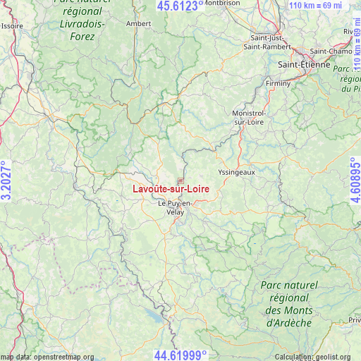
Lavoûte-sur-Loire GPS coordinates[2]
45° 7' 5.88" North, 3° 54' 20.952" East
| Map corner | latitude | longitude |
|---|---|---|
| Upper-left | 45.6123°, | 3.2027° |
| Center: | 45.1183°, | 3.90582° |
| Lower-right: | 44.61999°, | 4.60895° |
| Map W x H: | 110.3×110.3 km | = 68.5×68.5mi |
| max Lat: | 51.07786° ⇑78.3% North |
| Lavoûte-sur-Loire: | 45.1183° |
| min Lat: | ⇓21.7% South 41.3874° |
| min Long | Lavoûte-sur-Lo | max Long |
| -5.08615° | 3.90582° | 9.52242° |
| W 67%⇐ | ⇒33% E |
Elevation
Elevation of Lavoûte-sur-Loire is 565 m = 1854 ft, and this is 371.3 m = 1218 ft above average elevation for this country.
| Max E: |
2333 m = 7654 ft | 5.4% |
| Lavoûte-sur-Loire | 565 m 1854 ft | |
| Avg. | 193.7 m = 635 ft | |
Min E: |
-1 m = -3 ft | 94.6% |
See also: France elevation on elevation.city.
Geographical zone
Lavoûte-sur-Loire is located in North temperate zone (between Tropic of Cancer and the Arctic Circle). Distance of this North polar circle is 2384.5 km =1481.7 mi to North.| Distance of | km | miles | from Lavoûte-sur-Loire |
|---|---|---|---|
| North Pole | 4990.4 | 3100.9 | to North |
| Arctic Circle | 2384.5 | 1481.7 | to North |
| Tropic Cancer | 2410.8 | 1498 | to South |
| Equator | 5016.7 | 3117.2 | to South |


Nearby cities:
15 places around Lavoûte-sur-Loire: (largest is in red/bold)
• Blavozy
8.9 km =5.5 mi,  139°
139°
• Brives-Charensac
8 km =5 mi,  167°
167°
• Chadrac
6.3 km =3.9 mi,  182°
182°
• Chaspinhac
4.7 km =2.9 mi, 139°
• Espaly-Saint-Marcel
8.4 km =5.2 mi,  201°
201°
• Le Puy-en-Velay
8.5 km =5.3 mi,  191°
191°
• Malrevers
5.2 km =3.2 mi,  115°
115°
• Polignac
6.4 km =4 mi,  214°
214°
• Rosières
6.7 km =4.2 mi,  75°
75°
• Saint-Germain-Laprade
10.2 km =6.3 mi,  150°
150°
• Saint-Paulien
7.6 km =4.7 mi,  285°
285°
• Saint-Vincent
2.9 km =1.8 mi,  5°
5°
• Saint-Étienne-Lardeyrol
9.1 km =5.7 mi, 124°
• Vals-près-le-Puy
9.9 km =6.2 mi, 192°
• Vorey
7.6 km =4.7 mi,  2°
2°
Sources, notices
• [Note1] Compared only with cities in France existing in our database
• [Src1] Map data: © OpenStreetMap contributors (CC-BY-SA)
• [Src2] Other city data from geonames.org with taken over terms of usage.
• [Src3] Geographical zone / Annual Mean Temperature by Robert A. Rohde @ Wikipedia
