Laval geodata
Laval (Pays de la Loire) is a seat of a second-order administrative division; located in France in Europe/Paris (GMT+2) time zone. With population of 50,489 people, there are 124 cities with bigger population in this country. Compared to other cities in France, 60.7% of cities are located further ↓South; 86.1% of cities are located further →East and 73.1% of cities have higher elevation than Laval. Note1
Administrative division(s):
- Level 1: Pays de la Loire
- Level 2: Mayenne
- Level 3: Arrondissement de Laval
- Level 4: Laval


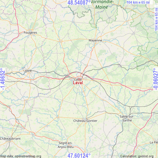
Laval GPS coordinates[2]
48° 4' 23.52" North, 0° 45' 48.24" West
| Map corner | latitude | longitude |
|---|---|---|
| Upper-left | 48.54087°, | -1.46652° |
| Center: | 48.0732°, | -0.7634° |
| Lower-right: | 47.60124°, | -0.06027° |
| Map W x H: | 104.5×104.5 km | = 64.9×64.9mi |
| max Lat: | 51.07786° ⇑39.3% North |
| Laval: | 48.0732° |
| min Lat: | ⇓60.7% South 41.3874° |
| min Long | Laval | max Long |
| -5.08615° | -0.7634° | 9.52242° |
| W 13.9%⇐ | ⇒86.1% E |
Elevation
Elevation of Laval is 71 m = 233 ft, and this is 122.7 m = 403 ft below average elevation for this country.
| Max E: |
2333 m = 7654 ft | 73.1% |
| Avg. | 193.7 m = 635 ft | |
| Laval | 71 m = 233 ft | |
Min E: |
-1 m = -3 ft | 26.9% |
See also: Laval elevation on elevation.city.
Geographical zone
Laval is located in North temperate zone (between Tropic of Cancer and the Arctic Circle). Distance of this North polar circle is 2055.9 km =1277.5 mi to North.| Distance of | km | miles | from Laval |
|---|---|---|---|
| North Pole | 4661.8 | 2896.7 | to North |
| Arctic Circle | 2055.9 | 1277.5 | to North |
| Tropic Cancer | 2739.3 | 1702.1 | to South |
| Equator | 5345.2 | 3321.4 | to South |


Nearby cities:
15 places around Laval: (largest is in red/bold)
• Ahuillé
9.8 km =6.1 mi,  233°
233°
• Argentré
9.1 km =5.7 mi,  82°
82°
• Bonchamp-lès-Laval
4.7 km =2.9 mi,  89°
89°
• Changé
3.6 km =2.2 mi,  322°
322°
• Entrammes
9.2 km =5.7 mi,  156°
156°
• Forcé
6.5 km =4 mi,  133°
133°
• La Chapelle-Anthenaise
8.5 km =5.3 mi,  49°
49°
• Louverné
6.4 km =4 mi,  32°
32°
• Louvigné
10 km =6.2 mi,  100°
100°
• Montigné-le-Brillant
8.1 km =5 mi,  208°
208°
• Nuillé-sur-Vicoin
9.9 km =6.2 mi,  188°
188°
• Parné-sur-Roc
10.3 km =6.4 mi,  136°
136°
• Saint-Berthevin
5.2 km =3.2 mi,  262°
262°
• Saint-Germain-le-Fouilloux
7.3 km =4.5 mi,  343°
343°
• Saint-Jean-sur-Mayenne
6.9 km =4.3 mi,  4°
4°
Sources, notices
• [Note1] Compared only with cities in France existing in our database
• [Src1] Map data: © OpenStreetMap contributors (CC-BY-SA)
• [Src2] Other city data from geonames.org with taken over terms of usage.
• [Src3] Geographical zone / Annual Mean Temperature by Robert A. Rohde @ Wikipedia
