Entrammes geodata
Entrammes (Pays de la Loire) is a populated place; located in France in Europe/Paris (GMT+2) time zone. With population of 1,951 people, there are 4909 cities with bigger population in this country. Compared to other cities in France, 59.2% of cities are located further ↓South; 85.7% of cities are located further →East and 78.2% of cities have higher elevation than Entrammes. Note1
Administrative division(s):
- Level 1: Pays de la Loire
- Level 2: Mayenne
- Level 3: Arrondissement de Laval
- Level 4: Entrammes


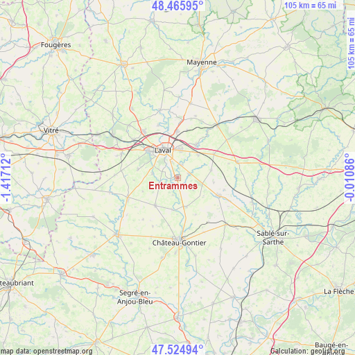
Entrammes GPS coordinates[2]
47° 59' 51.324" North, 0° 42' 50.364" West
| Map corner | latitude | longitude |
|---|---|---|
| Upper-left | 48.46595°, | -1.41712° |
| Center: | 47.99759°, | -0.71399° |
| Lower-right: | 47.52494°, | -0.01086° |
| Map W x H: | 104.6×104.6 km | = 65×65mi |
| max Lat: | 51.07786° ⇑40.8% North |
| Entrammes: | 47.99759° |
| min Lat: | ⇓59.2% South 41.3874° |
| min Long | Entrammes | max Long |
| -5.08615° | -0.71399° | 9.52242° |
| W 14.3%⇐ | ⇒85.7% E |
Elevation
Elevation of Entrammes is 59 m = 194 ft, and this is 134.7 m = 442 ft below average elevation for this country.
| Max E: |
2333 m = 7654 ft | 78.2% |
| Avg. | 193.7 m = 635 ft | |
| Entrammes | 59 m = 194 ft | |
Min E: |
-1 m = -3 ft | 21.8% |
See also: France elevation on elevation.city.
Geographical zone
Entrammes is located in North temperate zone (between Tropic of Cancer and the Arctic Circle). Distance of this North polar circle is 2064.3 km =1282.7 mi to North.| Distance of | km | miles | from Entrammes |
|---|---|---|---|
| North Pole | 4670.2 | 2901.9 | to North |
| Arctic Circle | 2064.3 | 1282.7 | to North |
| Tropic Cancer | 2730.9 | 1696.9 | to South |
| Equator | 5336.8 | 3316.1 | to South |


Nearby cities:
15 places around Entrammes: (largest is in red/bold)
• Ahuillé
11.8 km =7.3 mi,  282°
282°
• Argentré
11 km =6.8 mi,  29°
29°
• Arquenay
10.8 km =6.7 mi,  96°
96°
• Astillé
10.9 km =6.8 mi,  249°
249°
• Bazougers
10.1 km =6.3 mi,  77°
77°
• Bonchamp-lès-Laval
8.5 km =5.3 mi,  7°
7°
• Forcé
4.1 km =2.5 mi, 14°
• Laval
9.2 km =5.7 mi,  336°
336°
• Louvigné
9.1 km =5.7 mi,  42°
42°
• Montigné-le-Brillant
7.6 km =4.7 mi, 279°
• Nuillé-sur-Vicoin
5.3 km =3.3 mi,  255°
255°
• Parné-sur-Roc
3.5 km =2.2 mi,  74°
74°
• Quelaines-Saint-Gault
9.6 km =6 mi,  221°
221°
• Saint-Berthevin
11.7 km =7.3 mi,  310°
310°
• Villiers-Charlemagne
8.9 km =5.5 mi,  161°
161°
Sources, notices
• [Note1] Compared only with cities in France existing in our database
• [Src1] Map data: © OpenStreetMap contributors (CC-BY-SA)
• [Src2] Other city data from geonames.org with taken over terms of usage.
• [Src3] Geographical zone / Annual Mean Temperature by Robert A. Rohde @ Wikipedia
