Rogerville geodata
Rogerville (Normandy) is a populated place; located in France in Europe/Paris (GMT+2) time zone. With population of 1,282 people, there are 7120 cities with bigger population in this country. Compared to other cities in France, 89.3% of cities are located further ↓South; 75.6% of cities are located further →East and 63.2% of cities have higher elevation than Rogerville. Note1
Administrative division(s):
- Level 1: Normandy
- Level 2: Seine-Maritime
- Level 3: Arrondissement du Havre
- Level 4: Rogerville


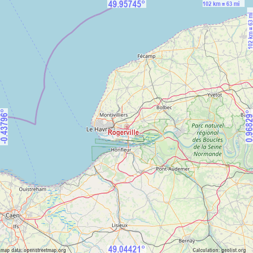
Rogerville GPS coordinates[2]
49° 30' 10.656" North, 0° 15' 54.576" East
| Map corner | latitude | longitude |
|---|---|---|
| Upper-left | 49.95745°, | -0.43796° |
| Center: | 49.50296°, | 0.26516° |
| Lower-right: | 49.04421°, | 0.96829° |
| Map W x H: | 101.5×101.5 km | = 63.1×63.1mi |
| max Lat: | 51.07786° ⇑10.7% North |
| Rogerville: | 49.50296° |
| min Lat: | ⇓89.3% South 41.3874° |
| min Long | Rogerville | max Long |
| -5.08615° | 0.26516° | 9.52242° |
| W 24.4%⇐ | ⇒75.6% E |
Elevation
Elevation of Rogerville is 94 m = 308 ft, and this is 99.7 m = 327 ft below average elevation for this country.
| Max E: |
2333 m = 7654 ft | 63.2% |
| Avg. | 193.7 m = 635 ft | |
| Rogerville | 94 m = 308 ft | |
Min E: |
-1 m = -3 ft | 36.8% |
See also: France elevation on elevation.city.
Geographical zone
Rogerville is located in North temperate zone (between Tropic of Cancer and the Arctic Circle). Distance of this North polar circle is 1897 km =1178.7 mi to North.| Distance of | km | miles | from Rogerville |
|---|---|---|---|
| North Pole | 4502.8 | 2797.9 | to North |
| Arctic Circle | 1897 | 1178.7 | to North |
| Tropic Cancer | 2898.3 | 1800.9 | to South |
| Equator | 5504.2 | 3420.2 | to South |


Nearby cities:
15 places around Rogerville: (largest is in red/bold)
• Fontenay
8.6 km =5.3 mi,  317°
317°
• Gainneville
1.7 km =1.1 mi,  351°
351°
• Harfleur
4.8 km =3 mi,  274°
274°
• Manéglise
7 km =4.3 mi, 354°
• Montivilliers
7.3 km =4.5 mi,  310°
310°
• Sainneville
6.1 km =3.8 mi,  15°
15°
• Saint-Aubin-Routot
4.9 km =3 mi,  62°
62°
• Saint-Laurent-de-Brévedent
2.6 km =1.6 mi,  343°
343°
• Saint-Martin-du-Manoir
3.8 km =2.4 mi,  328°
328°
• Saint-Romain-de-Colbosc
7.3 km =4.5 mi, 64°
• Saint-Vincent-Cramesnil
6.9 km =4.3 mi,  90°
90°
• Sandouville
3.8 km =2.4 mi,  98°
98°
• Épouville
7.4 km =4.6 mi, 336°
• Épretot
5.5 km =3.4 mi,  42°
42°
• Étainhus
7.9 km =4.9 mi,  25°
25°
Sources, notices
• [Note1] Compared only with cities in France existing in our database
• [Src1] Map data: © OpenStreetMap contributors (CC-BY-SA)
• [Src2] Other city data from geonames.org with taken over terms of usage.
• [Src3] Geographical zone / Annual Mean Temperature by Robert A. Rohde @ Wikipedia
