Lapeyrouse-Fossat geodata
Lapeyrouse-Fossat (Occitanie) is a populated place; located in France in Europe/Paris (GMT+2) time zone. With population of 2,308 people, there are 4179 cities with bigger population in this country. Compared to other cities in France, 90.4% of cities are located further ↑North; 62.9% of cities are located further →East and 63.3% of cities have lower elevation than Lapeyrouse-Fossat. Note1
Administrative division(s):
- Level 1: Occitanie
- Level 2: Haute-Garonne
- Level 3: Arrondissement de Toulouse
- Level 4: Lapeyrouse-Fossat


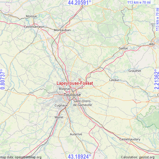
Lapeyrouse-Fossat GPS coordinates[2]
43° 41' 59.028" North, 1° 30' 37.764" East
| Map corner | latitude | longitude |
|---|---|---|
| Upper-left | 44.20591°, | 0.80737° |
| Center: | 43.69973°, | 1.51049° |
| Lower-right: | 43.18924°, | 2.21362° |
| Map W x H: | 113×113 km | = 70.2×70.2mi |
| max Lat: | 51.07786° ⇑90.4% North |
| Lapeyrouse-Fossat: | 43.69973° |
| min Lat: | ⇓9.6% South 41.3874° |
| min Long | Lapeyrouse-Foss | max Long |
| -5.08615° | 1.51049° | 9.52242° |
| W 37.1%⇐ | ⇒62.9% E |
Elevation
Elevation of Lapeyrouse-Fossat is 186 m = 610 ft, and this is 7.7 m = 25 ft below average elevation for this country.
| Max E: |
2333 m = 7654 ft | 36.7% |
| Avg. | 193.7 m = 635 ft | |
| Lapeyrouse-Fossat | 186 m = 610 ft | |
Min E: |
-1 m = -3 ft | 63.3% |
See also: France elevation on elevation.city.
Geographical zone
Lapeyrouse-Fossat is located in North temperate zone (between Tropic of Cancer and the Arctic Circle). Distance of this Northern Tropic circle is 2253 km =1399.9 mi to South.| Distance of | km | miles | from Lapeyrouse-Fossat |
|---|---|---|---|
| North Pole | 5148.1 | 3198.9 | to North |
| Arctic Circle | 2542.2 | 1579.6 | to North |
| Tropic Cancer | 2253 | 1399.9 | to South |
| Equator | 4859 | 3019.2 | to South |


Nearby cities:
15 places around Lapeyrouse-Fossat: (largest is in red/bold)
• Bazus
3.9 km =2.4 mi,  6°
6°
• Castelginest
6.2 km =3.9 mi,  263°
263°
• Castelmaurou
3 km =1.9 mi,  144°
144°
• Garidech
4.2 km =2.6 mi,  72°
72°
• L'Union
4.9 km =3 mi,  207°
207°
• Labastide-Saint-Sernin
5.3 km =3.3 mi,  322°
322°
• Launaguet
5 km =3.1 mi,  241°
241°
• Montberon
3.1 km =1.9 mi,  305°
305°
• Montrabé
6.2 km =3.9 mi,  170°
170°
• Pechbonnieu
3.6 km =2.2 mi,  274°
274°
• Rouffiac-Tolosan
4 km =2.5 mi,  162°
162°
• Saint-Geniès-Bellevue
2.6 km =1.6 mi,  227°
227°
• Saint-Jean
4 km =2.5 mi,  192°
192°
• Saint-Loup-Cammas
2.4 km =1.5 mi, 264°
• Villariès
5.9 km =3.7 mi,  344°
344°
Sources, notices
• [Note1] Compared only with cities in France existing in our database
• [Src1] Map data: © OpenStreetMap contributors (CC-BY-SA)
• [Src2] Other city data from geonames.org with taken over terms of usage.
• [Src3] Geographical zone / Annual Mean Temperature by Robert A. Rohde @ Wikipedia
