Bazus geodata
Bazus (Occitanie) is a populated place; located in France in Europe/Paris (GMT+2) time zone. With population of 599 people, there are 13333 cities with bigger population in this country. Compared to other cities in France, 89.9% of cities are located further ↑North; 62.8% of cities are located further →East and 62.5% of cities have lower elevation than Bazus. Note1
Administrative division(s):
- Level 1: Occitanie
- Level 2: Haute-Garonne
- Level 3: Arrondissement de Toulouse
- Level 4: Bazus


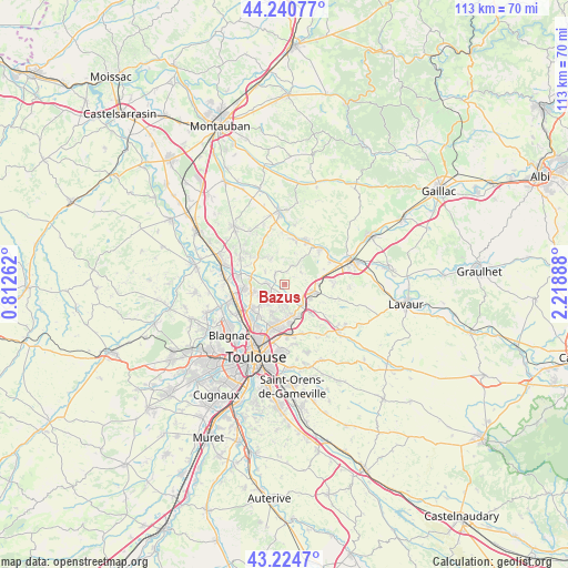
Bazus GPS coordinates[2]
43° 44' 5.604" North, 1° 30' 56.7" East
| Map corner | latitude | longitude |
|---|---|---|
| Upper-left | 44.24077°, | 0.81262° |
| Center: | 43.73489°, | 1.51575° |
| Lower-right: | 43.2247°, | 2.21888° |
| Map W x H: | 113×113 km | = 70.2×70.2mi |
| max Lat: | 51.07786° ⇑89.9% North |
| Bazus: | 43.73489° |
| min Lat: | ⇓10.1% South 41.3874° |
| min Long | Bazus | max Long |
| -5.08615° | 1.51575° | 9.52242° |
| W 37.2%⇐ | ⇒62.8% E |
Elevation
Elevation of Bazus is 182 m = 597 ft, and this is 11.7 m = 38 ft below average elevation for this country.
| Max E: |
2333 m = 7654 ft | 37.5% |
| Avg. | 193.7 m = 635 ft | |
| Bazus | 182 m = 597 ft | |
Min E: |
-1 m = -3 ft | 62.5% |
See also: France elevation on elevation.city.
Geographical zone
Bazus is located in North temperate zone (between Tropic of Cancer and the Arctic Circle). Distance of this Northern Tropic circle is 2256.9 km =1402.4 mi to South.| Distance of | km | miles | from Bazus |
|---|---|---|---|
| North Pole | 5144.2 | 3196.5 | to North |
| Arctic Circle | 2538.3 | 1577.2 | to North |
| Tropic Cancer | 2256.9 | 1402.4 | to South |
| Equator | 4862.9 | 3021.7 | to South |


Nearby cities:
15 places around Bazus: (largest is in red/bold)
• Castelmaurou
6.5 km =4 mi,  168°
168°
• Gargas
4.6 km =2.9 mi,  302°
302°
• Garidech
4.5 km =2.8 mi,  126°
126°
• Gratentour
6.8 km =4.2 mi,  259°
259°
• Labastide-Saint-Sernin
3.7 km =2.3 mi,  274°
274°
• Lapeyrouse-Fossat
3.9 km =2.4 mi,  186°
186°
• Montastruc-la-Conseillère
6.2 km =3.9 mi,  105°
105°
• Montberon
3.6 km =2.2 mi,  233°
233°
• Montjoire
4.1 km =2.5 mi,  20°
20°
• Paulhac
4.1 km =2.5 mi,  53°
53°
• Pechbonnieu
5.4 km =3.4 mi, 228°
• Saint-Geniès-Bellevue
6.1 km =3.8 mi,  202°
202°
• Saint-Loup-Cammas
5 km =3.1 mi,  213°
213°
• Vacquiers
5.4 km =3.4 mi,  329°
329°
• Villariès
2.6 km =1.6 mi,  311°
311°
Sources, notices
• [Note1] Compared only with cities in France existing in our database
• [Src1] Map data: © OpenStreetMap contributors (CC-BY-SA)
• [Src2] Other city data from geonames.org with taken over terms of usage.
• [Src3] Geographical zone / Annual Mean Temperature by Robert A. Rohde @ Wikipedia
