Labastide-Saint-Sernin geodata
Labastide-Saint-Sernin (Occitanie) is a populated place; located in France in Europe/Paris (GMT+2) time zone. With population of 1,499 people, there are 6192 cities with bigger population in this country. Compared to other cities in France, 89.9% of cities are located further ↑North; 63.4% of cities are located further →East and 51.9% of cities have lower elevation than Labastide-Saint-Sernin. Note1
Administrative division(s):
- Level 1: Occitanie
- Level 2: Haute-Garonne
- Level 3: Arrondissement de Toulouse
- Level 4: Labastide-Saint-Sernin
Current local time in Labastide-Saint-Sernin:
04:18 AM, WednesdayDifference from your time zone: hours


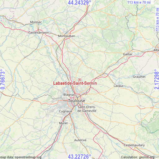
Labastide-Saint-Sernin GPS coordinates[2]
43° 44' 14.748" North, 1° 28' 11.46" East
| Map corner | latitude | longitude |
|---|---|---|
| Upper-left | 44.24329°, | 0.76673° |
| Center: | 43.73743°, | 1.46985° |
| Lower-right: | 43.22726°, | 2.17298° |
| Map W x H: | 113×113 km | = 70.2×70.2mi |
| max Lat: | 51.07786° ⇑89.9% North |
| Labastide-Saint-Sernin: | 43.73743° |
| min Lat: | ⇓10.1% South 41.3874° |
| min Long | Labastide-Saint | max Long |
| -5.08615° | 1.46985° | 9.52242° |
| W 36.6%⇐ | ⇒63.4% E |
Elevation
Elevation of Labastide-Saint-Sernin is 139 m = 456 ft, and this is 54.7 m = 179 ft below average elevation for this country.
| Max E: |
2333 m = 7654 ft | 48.1% |
| Avg. | 193.7 m = 635 ft | |
| Labastide-Saint-Sernin | 139 m = 456 ft | |
Min E: |
-1 m = -3 ft | 51.9% |
See also: France elevation on elevation.city.
Geographical zone
Labastide-Saint-Sernin is located in North temperate zone (between Tropic of Cancer and the Arctic Circle). Distance of this Northern Tropic circle is 2257.2 km =1402.6 mi to South.| Distance of | km | miles | from Labastide-Saint-Sernin |
|---|---|---|---|
| North Pole | 5143.9 | 3196.3 | to North |
| Arctic Circle | 2538 | 1577 | to North |
| Tropic Cancer | 2257.2 | 1402.6 | to South |
| Equator | 4863.1 | 3021.8 | to South |


Nearby cities:
15 places around Labastide-Saint-Sernin: (largest is in red/bold)
• Bazus
3.7 km =2.3 mi,  94°
94°
• Bruguières
5.1 km =3.2 mi,  257°
257°
• Castelginest
5.6 km =3.5 mi,  210°
210°
• Cépet
3.3 km =2.1 mi,  292°
292°
• Gargas
2.2 km =1.4 mi,  355°
355°
• Gratentour
3.4 km =2.1 mi,  242°
242°
• Lapeyrouse-Fossat
5.3 km =3.3 mi,  142°
142°
• Montberon
2.5 km =1.6 mi,  161°
161°
• Pechbonnieu
3.9 km =2.4 mi,  185°
185°
• Saint-Geniès-Bellevue
6.1 km =3.8 mi,  166°
166°
• Saint-Loup-Cammas
4.5 km =2.8 mi, 168°
• Saint-Sauveur
5.7 km =3.5 mi,  282°
282°
• Vacquiers
4.5 km =2.8 mi,  11°
11°
• Villariès
2.3 km =1.4 mi,  49°
49°
• Villeneuve-lès-Bouloc
5.1 km =3.2 mi,  311°
311°
Sources, notices
• [Note1] Compared only with cities in France existing in our database
• [Src1] Map data: © OpenStreetMap contributors (CC-BY-SA)
• [Src2] Other city data from geonames.org with taken over terms of usage.
• [Src3] Geographical zone / Annual Mean Temperature by Robert A. Rohde @ Wikipedia
