Garidech geodata
Garidech (Occitanie) is a populated place; located in France in Europe/Paris (GMT+2) time zone. With population of 1,072 people, there are 8316 cities with bigger population in this country. Compared to other cities in France, 90.2% of cities are located further ↑North; 62.2% of cities are located further →East and 64.6% of cities have lower elevation than Garidech. Note1
Administrative division(s):
- Level 1: Occitanie
- Level 2: Haute-Garonne
- Level 3: Arrondissement de Toulouse
- Level 4: Garidech


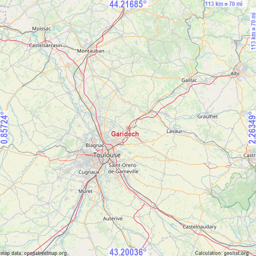
Garidech GPS coordinates[2]
43° 42' 38.736" North, 1° 33' 37.296" East
| Map corner | latitude | longitude |
|---|---|---|
| Upper-left | 44.21685°, | 0.85724° |
| Center: | 43.71076°, | 1.56036° |
| Lower-right: | 43.20036°, | 2.26349° |
| Map W x H: | 113×113 km | = 70.2×70.2mi |
| max Lat: | 51.07786° ⇑90.2% North |
| Garidech: | 43.71076° |
| min Lat: | ⇓9.8% South 41.3874° |
| min Long | Garidech | max Long |
| -5.08615° | 1.56036° | 9.52242° |
| W 37.8%⇐ | ⇒62.2% E |
Elevation
Elevation of Garidech is 192 m = 630 ft, and this is 1.7 m = 6 ft below average elevation for this country.
| Max E: |
2333 m = 7654 ft | 35.4% |
| Avg. | 193.7 m = 635 ft | |
| Garidech | 192 m = 630 ft | |
Min E: |
-1 m = -3 ft | 64.6% |
See also: France elevation on elevation.city.
Geographical zone
Garidech is located in North temperate zone (between Tropic of Cancer and the Arctic Circle). Distance of this Northern Tropic circle is 2254.3 km =1400.8 mi to South.| Distance of | km | miles | from Garidech |
|---|---|---|---|
| North Pole | 5146.9 | 3198.1 | to North |
| Arctic Circle | 2541 | 1578.9 | to North |
| Tropic Cancer | 2254.3 | 1400.8 | to South |
| Equator | 4860.2 | 3020 | to South |


Nearby cities:
15 places around Garidech: (largest is in red/bold)
• Bazus
4.5 km =2.8 mi,  306°
306°
• Beaupuy
7.1 km =4.4 mi,  183°
183°
• Castelmaurou
4.3 km =2.7 mi,  211°
211°
• Gragnague
3.8 km =2.4 mi,  149°
149°
• Lapeyrouse-Fossat
4.2 km =2.6 mi,  252°
252°
• Montastruc-la-Conseillère
2.6 km =1.6 mi,  67°
67°
• Montberon
6.5 km =4 mi,  274°
274°
• Montjoire
6.8 km =4.2 mi,  341°
341°
• Paulhac
5.1 km =3.2 mi,  356°
356°
• Roquesérière
6.7 km =4.2 mi, 66°
• Rouffiac-Tolosan
5.7 km =3.5 mi, 209°
• Saint-Geniès-Bellevue
6.6 km =4.1 mi,  243°
243°
• Saint-Jean
7.1 km =4.4 mi,  223°
223°
• Saint-Loup-Cammas
6.5 km =4 mi,  257°
257°
• Villariès
7.1 km =4.4 mi, 308°
Sources, notices
• [Note1] Compared only with cities in France existing in our database
• [Src1] Map data: © OpenStreetMap contributors (CC-BY-SA)
• [Src2] Other city data from geonames.org with taken over terms of usage.
• [Src3] Geographical zone / Annual Mean Temperature by Robert A. Rohde @ Wikipedia
