Landudal geodata
Landudal (Brittany) is a populated place; located in France in Europe/Paris (GMT+2) time zone. With population of 739 people, there are 11303 cities with bigger population in this country. Compared to other cities in France, 60.4% of cities are located further ↓South; 99% of cities are located further →East and 53.8% of cities have higher elevation than Landudal. Note1
Administrative division(s):
- Level 1: Brittany
- Level 2: Département du Finistère
- Level 3: Arrondissement de Quimper
- Level 4: Landudal


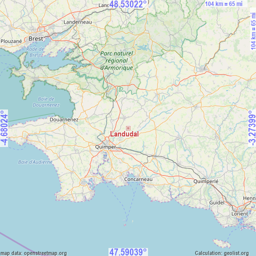
Landudal GPS coordinates[2]
48° 3' 44.82" North, 3° 58' 37.596" West
| Map corner | latitude | longitude |
|---|---|---|
| Upper-left | 48.53022°, | -4.68024° |
| Center: | 48.06245°, | -3.97711° |
| Lower-right: | 47.59039°, | -3.27399° |
| Map W x H: | 104.5×104.5 km | = 64.9×64.9mi |
| max Lat: | 51.07786° ⇑39.6% North |
| Landudal: | 48.06245° |
| min Lat: | ⇓60.4% South 41.3874° |
| min Long | Landudal | max Long |
| -5.08615° | -3.97711° | 9.52242° |
| W 1%⇐ | ⇒99% E |
Elevation
Elevation of Landudal is 120 m = 394 ft, and this is 73.7 m = 242 ft below average elevation for this country.
| Max E: |
2333 m = 7654 ft | 53.8% |
| Avg. | 193.7 m = 635 ft | |
| Landudal | 120 m = 394 ft | |
Min E: |
-1 m = -3 ft | 46.2% |
See also: France elevation on elevation.city.
Geographical zone
Landudal is located in North temperate zone (between Tropic of Cancer and the Arctic Circle). Distance of this North polar circle is 2057.1 km =1278.2 mi to North.| Distance of | km | miles | from Landudal |
|---|---|---|---|
| North Pole | 4663 | 2897.5 | to North |
| Arctic Circle | 2057.1 | 1278.2 | to North |
| Tropic Cancer | 2738.1 | 1701.4 | to South |
| Equator | 5344 | 3320.6 | to South |


Nearby cities:
15 places around Landudal: (largest is in red/bold)
• Briec
4.6 km =2.9 mi,  340°
340°
• Coray
10.9 km =6.8 mi,  91°
91°
• Edern
4.2 km =2.6 mi,  353°
353°
• Elliant
10 km =6.2 mi,  139°
139°
• Ergué-Gabéric
8.2 km =5.1 mi,  204°
204°
• Gouézec
11.9 km =7.4 mi,  1°
1°
• Landrévarzec
7 km =4.3 mi,  297°
297°
• Langolen
4.8 km =3 mi,  83°
83°
• Laz
13.5 km =8.4 mi,  51°
51°
• Quimper
11.5 km =7.1 mi,  232°
232°
• Quéménéven
12 km =7.5 mi, 300°
• Saint-Thois
13.5 km =8.4 mi,  30°
30°
• Saint-Yvi
11.1 km =6.9 mi,  162°
162°
• Tourch
11.2 km =7 mi,  106°
106°
• Trégourez
9.2 km =5.7 mi,  63°
63°
Sources, notices
• [Note1] Compared only with cities in France existing in our database
• [Src1] Map data: © OpenStreetMap contributors (CC-BY-SA)
• [Src2] Other city data from geonames.org with taken over terms of usage.
• [Src3] Geographical zone / Annual Mean Temperature by Robert A. Rohde @ Wikipedia
