Quimper geodata
Quimper (Brittany) is a seat of a second-order administrative division; located in France in Europe/Paris (GMT+2) time zone. With population of 63,849 people, there are 73 cities with bigger population in this country. Compared to other cities in France, 59.3% of cities are located further ↓South; 99.1% of cities are located further →East and 87.4% of cities have higher elevation than Quimper. Note1
Administrative division(s):
- Level 1: Brittany
- Level 2: Département du Finistère
- Level 3: Arrondissement de Quimper
- Level 4: Quimper


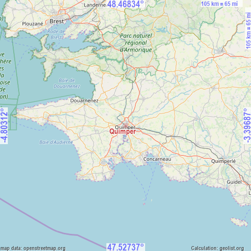
Quimper GPS coordinates[2]
48° 0' 0" North, 4° 6' 0" West
| Map corner | latitude | longitude |
|---|---|---|
| Upper-left | 48.46834°, | -4.80312° |
| Center: | 48°, | -4.1° |
| Lower-right: | 47.52737°, | -3.39687° |
| Map W x H: | 104.6×104.6 km | = 65×65mi |
| max Lat: | 51.07786° ⇑40.7% North |
| Quimper: | 48° |
| min Lat: | ⇓59.3% South 41.3874° |
| min Long | Quimper | max Long |
| -5.08615° | -4.1° | 9.52242° |
| W 0.9%⇐ | ⇒99.1% E |
Elevation
Elevation of Quimper is 36 m = 118 ft, and this is 157.7 m = 517 ft below average elevation for this country.
| Max E: |
2333 m = 7654 ft | 87.4% |
| Avg. | 193.7 m = 635 ft | |
| Quimper | 36 m = 118 ft | |
Min E: |
-1 m = -3 ft | 12.6% |
See also: Quimper elevation on elevation.city.
Geographical zone
Quimper is located in North temperate zone (between Tropic of Cancer and the Arctic Circle). Distance of this North polar circle is 2064.1 km =1282.6 mi to North.| Distance of | km | miles | from Quimper |
|---|---|---|---|
| North Pole | 4670 | 2901.8 | to North |
| Arctic Circle | 2064.1 | 1282.6 | to North |
| Tropic Cancer | 2731.2 | 1697.1 | to South |
| Equator | 5337.1 | 3316.3 | to South |


Nearby cities:
15 places around Quimper: (largest is in red/bold)
• Clohars-Fouesnant
11.8 km =7.3 mi,  166°
166°
• Ergué-Gabéric
5.8 km =3.6 mi,  94°
94°
• Gouesnach
10 km =6.2 mi,  186°
186°
• Gourlizon
12.5 km =7.8 mi,  279°
279°
• Guengat
9.1 km =5.7 mi,  300°
300°
• Landrévarzec
10.6 km =6.6 mi,  16°
16°
• Landudal
11.5 km =7.1 mi,  52°
52°
• Pleuven
12.2 km =7.6 mi,  155°
155°
• Plogastel-Saint-Germain
12.5 km =7.8 mi,  261°
261°
• Plogonnec
11.1 km =6.9 mi,  326°
326°
• Plomelin
8.3 km =5.2 mi,  206°
206°
• Plonéis
8.9 km =5.5 mi, 282°
• Pluguffan
6.5 km =4 mi,  253°
253°
• Saint-Yvi
12.9 km =8 mi,  106°
106°
• Saint-Évarzec
9.7 km =6 mi,  140°
140°
Sources, notices
• [Note1] Compared only with cities in France existing in our database
• [Src1] Map data: © OpenStreetMap contributors (CC-BY-SA)
• [Src2] Other city data from geonames.org with taken over terms of usage.
• [Src3] Geographical zone / Annual Mean Temperature by Robert A. Rohde @ Wikipedia
