Landéan geodata
Landéan (Brittany) is a populated place; located in France in Europe/Paris (GMT+2) time zone. With population of 1,314 people, there are 6959 cities with bigger population in this country. Compared to other cities in France, 66.6% of cities are located further ↓South; 89.6% of cities are located further →East and 53.6% of cities have lower elevation than Landéan. Note1
Administrative division(s):
- Level 1: Brittany
- Level 2: Département d'Ille-et-Vilaine
- Level 3: Arrondissement de Fougères-Vitré
- Level 4: Landéan


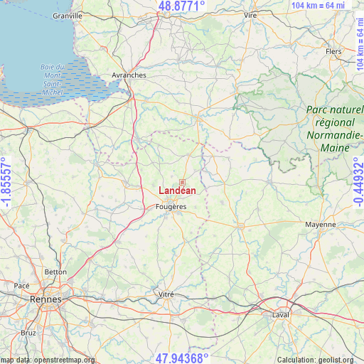
Landéan GPS coordinates[2]
48° 24' 45.108" North, 1° 9' 8.82" West
| Map corner | latitude | longitude |
|---|---|---|
| Upper-left | 48.8771°, | -1.85557° |
| Center: | 48.41253°, | -1.15245° |
| Lower-right: | 47.94368°, | -0.44932° |
| Map W x H: | 103.8×103.8 km | = 64.5×64.5mi |
| max Lat: | 51.07786° ⇑33.4% North |
| Landéan: | 48.41253° |
| min Lat: | ⇓66.6% South 41.3874° |
| min Long | Landéan | max Long |
| -5.08615° | -1.15245° | 9.52242° |
| W 10.4%⇐ | ⇒89.6% E |
Elevation
Elevation of Landéan is 145 m = 476 ft, and this is 48.7 m = 160 ft below average elevation for this country.
| Max E: |
2333 m = 7654 ft | 46.4% |
| Avg. | 193.7 m = 635 ft | |
| Landéan | 145 m = 476 ft | |
Min E: |
-1 m = -3 ft | 53.6% |
See also: France elevation on elevation.city.
Geographical zone
Landéan is located in North temperate zone (between Tropic of Cancer and the Arctic Circle). Distance of this North polar circle is 2018.2 km =1254.1 mi to North.| Distance of | km | miles | from Landéan |
|---|---|---|---|
| North Pole | 4624.1 | 2873.3 | to North |
| Arctic Circle | 2018.2 | 1254.1 | to North |
| Tropic Cancer | 2777 | 1725.5 | to South |
| Equator | 5383 | 3344.8 | to South |


Nearby cities:
15 places around Landéan: (largest is in red/bold)
• Beaucé
8.2 km =5.1 mi,  182°
182°
• Fleurigné
8.8 km =5.5 mi,  165°
165°
• Fougères
7.6 km =4.7 mi,  207°
207°
• Javené
11.4 km =7.1 mi,  204°
204°
• La Chapelle-Janson
8.1 km =5 mi,  152°
152°
• Laignelet
4.8 km =3 mi, 178°
• Landivy
11.5 km =7.1 mi,  50°
50°
• Le Loroux
6.7 km =4.2 mi,  107°
107°
• Louvigné-du-Désert
7.8 km =4.8 mi,  14°
14°
• Lécousse
7 km =4.3 mi,  219°
219°
• Mellé
8.7 km =5.4 mi,  342°
342°
• Parigné
3.4 km =2.1 mi,  299°
299°
• Pontmain
7.3 km =4.5 mi,  65°
65°
• Saint-Germain-en-Coglès
8.2 km =5.1 mi,  264°
264°
• Saint-Mars-sur-la-Futaie
10.3 km =6.4 mi,  78°
78°
Sources, notices
• [Note1] Compared only with cities in France existing in our database
• [Src1] Map data: © OpenStreetMap contributors (CC-BY-SA)
• [Src2] Other city data from geonames.org with taken over terms of usage.
• [Src3] Geographical zone / Annual Mean Temperature by Robert A. Rohde @ Wikipedia
