Fougères geodata
Fougères (Brittany) is a seat of a third-order administrative division; located in France in Europe/Paris (GMT+2) time zone. With population of 23,719 people, there are 374 cities with bigger population in this country. Compared to other cities in France, 65.5% of cities are located further ↓South; 90% of cities are located further →East and 61.2% of cities have higher elevation than Fougères. Note1
Administrative division(s):
- Level 1: Brittany
- Level 2: Département d'Ille-et-Vilaine
- Level 3: Arrondissement de Fougères-Vitré
- Level 4: Fougères


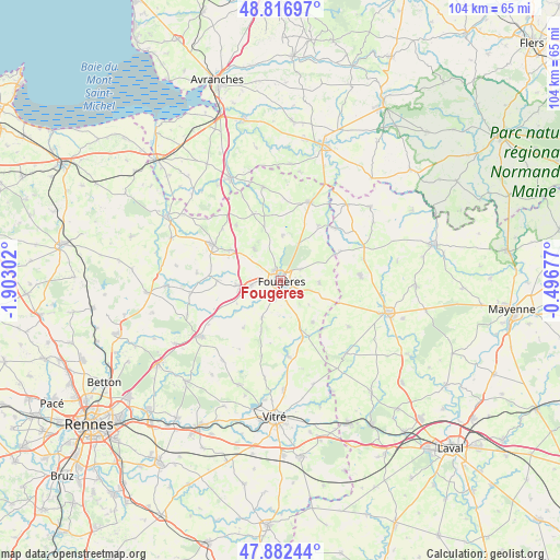
Fougères GPS coordinates[2]
48° 21' 6.66" North, 1° 11' 59.604" West
| Map corner | latitude | longitude |
|---|---|---|
| Upper-left | 48.81697°, | -1.90302° |
| Center: | 48.35185°, | -1.19989° |
| Lower-right: | 47.88244°, | -0.49677° |
| Map W x H: | 103.9×103.9 km | = 64.6×64.6mi |
| max Lat: | 51.07786° ⇑34.5% North |
| Fougères: | 48.35185° |
| min Lat: | ⇓65.5% South 41.3874° |
| min Long | Fougères | max Long |
| -5.08615° | -1.19989° | 9.52242° |
| W 10%⇐ | ⇒90% E |
Elevation
Elevation of Fougères is 99 m = 325 ft, and this is 94.7 m = 311 ft below average elevation for this country.
| Max E: |
2333 m = 7654 ft | 61.2% |
| Avg. | 193.7 m = 635 ft | |
| Fougères | 99 m = 325 ft | |
Min E: |
-1 m = -3 ft | 38.8% |
See also: France elevation on elevation.city.
Geographical zone
Fougères is located in North temperate zone (between Tropic of Cancer and the Arctic Circle). Distance of this North polar circle is 2025 km =1258.3 mi to North.| Distance of | km | miles | from Fougères |
|---|---|---|---|
| North Pole | 4630.8 | 2877.4 | to North |
| Arctic Circle | 2025 | 1258.3 | to North |
| Tropic Cancer | 2770.3 | 1721.4 | to South |
| Equator | 5376.2 | 3340.6 | to South |


Nearby cities:
15 places around Fougères: (largest is in red/bold)
• Beaucé
3.4 km =2.1 mi,  114°
114°
• Billé
7.9 km =4.9 mi,  205°
205°
• Fleurigné
6 km =3.7 mi, 107°
• Javené
3.8 km =2.4 mi,  198°
198°
• La Chapelle-Janson
7.2 km =4.5 mi,  93°
93°
• La Selle-en-Luitré
7 km =4.3 mi,  130°
130°
• Laignelet
4.1 km =2.5 mi,  61°
61°
• Landéan
7.6 km =4.7 mi,  27°
27°
• Luitré
9.8 km =6.1 mi,  142°
142°
• Lécousse
1.7 km =1.1 mi,  325°
325°
• Parcé
8.8 km =5.5 mi,  180°
180°
• Parigné
8.4 km =5.2 mi,  3°
3°
• Romagné
5.9 km =3.7 mi,  257°
257°
• Saint-Germain-en-Coglès
7.6 km =4.7 mi,  321°
321°
• Saint-Sauveur-des-Landes
8.4 km =5.2 mi, 263°
Sources, notices
• [Note1] Compared only with cities in France existing in our database
• [Src1] Map data: © OpenStreetMap contributors (CC-BY-SA)
• [Src2] Other city data from geonames.org with taken over terms of usage.
• [Src3] Geographical zone / Annual Mean Temperature by Robert A. Rohde @ Wikipedia
