Cerzat geodata
Cerzat (Auvergne-Rhône-Alpes) is a seat of a fourth-order administrative division; located in France in Europe/Paris (GMT+2) time zone. With population of 211 people, there are 15239 cities with bigger population in this country. Compared to other cities in France, 77.9% of cities are located further ↑North; 64% of cities are located further ←West and 95.2% of cities have lower elevation than Cerzat. Note1
Administrative division(s):
- Level 1: Auvergne-Rhône-Alpes
- Level 2: Haute-Loire
- Level 3: Arrondissement de Brioude
- Level 4: Cerzat


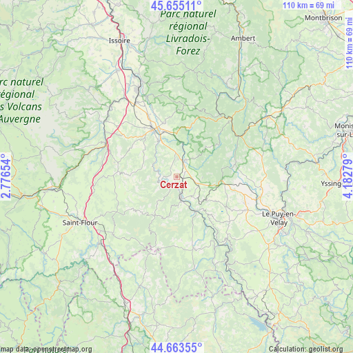
Cerzat GPS coordinates[2]
45° 9' 41.364" North, 3° 28' 46.776" East
| Map corner | latitude | longitude |
|---|---|---|
| Upper-left | 45.65511°, | 2.77654° |
| Center: | 45.16149°, | 3.47966° |
| Lower-right: | 44.66355°, | 4.18279° |
| Map W x H: | 110.3×110.3 km | = 68.5×68.5mi |
| max Lat: | 51.07786° ⇑77.9% North |
| Cerzat: | 45.16149° |
| min Lat: | ⇓22.1% South 41.3874° |
| min Long | Cerzat | max Long |
| -5.08615° | 3.47966° | 9.52242° |
| W 64%⇐ | ⇒36% E |
Elevation
Elevation of Cerzat is 599 m = 1965 ft, and this is 405.3 m = 1330 ft above average elevation for this country.
| Max E: |
2333 m = 7654 ft | 4.8% |
| Cerzat | 599 m 1965 ft | |
| Avg. | 193.7 m = 635 ft | |
Min E: |
-1 m = -3 ft | 95.2% |
See also: France elevation on elevation.city.
Geographical zone
Cerzat is located in North temperate zone (between Tropic of Cancer and the Arctic Circle). Distance of this North polar circle is 2379.7 km =1478.7 mi to North.| Distance of | km | miles | from Cerzat |
|---|---|---|---|
| North Pole | 4985.6 | 3097.9 | to North |
| Arctic Circle | 2379.7 | 1478.7 | to North |
| Tropic Cancer | 2415.6 | 1501 | to South |
| Equator | 5021.5 | 3120.2 | to South |


Nearby cities:
15 places around Cerzat: (largest is in red/bold)
• Allègre
18.7 km =11.6 mi,  76°
76°
• Bournoncle-Saint-Pierre
23.9 km =14.9 mi,  328°
328°
• Brioude
16.5 km =10.3 mi, 333°
• Chaspuzac
23.6 km =14.7 mi,  116°
116°
• Cohade
21.3 km =13.2 mi,  336°
336°
• La Chaise-Dieu
24.6 km =15.3 mi,  43°
43°
• Lamothe
17.4 km =10.8 mi,  345°
345°
• Langeac
6.9 km =4.3 mi,  170°
170°
• Loudes
22.6 km =14 mi,  111°
111°
• Massiac
24.3 km =15.1 mi,  294°
294°
• Paulhac
18.6 km =11.6 mi, 326°
• Paulhaguet
5.8 km =3.6 mi,  27°
27°
• Saint-Paulien
26.3 km =16.3 mi,  96°
96°
• Saugues
23 km =14.3 mi, 166°
• Vieille-Brioude
12.9 km =8 mi, 332°
Sources, notices
• [Note1] Compared only with cities in France existing in our database
• [Src1] Map data: © OpenStreetMap contributors (CC-BY-SA)
• [Src2] Other city data from geonames.org with taken over terms of usage.
• [Src3] Geographical zone / Annual Mean Temperature by Robert A. Rohde @ Wikipedia
