Lalbenque geodata
Lalbenque (Occitanie) is a populated place; located in France in Europe/Paris (GMT+2) time zone. With population of 1,142 people, there are 7876 cities with bigger population in this country. Compared to other cities in France, 84.6% of cities are located further ↑North; 62.4% of cities are located further →East and 78.5% of cities have lower elevation than Lalbenque. Note1
Administrative division(s):
- Level 1: Occitanie
- Level 2: Lot
- Level 3: Arrondissement de Cahors
- Level 4: Lalbenque


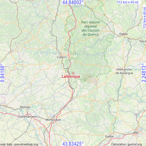
Lalbenque GPS coordinates[2]
44° 20' 21.444" North, 1° 32' 42.036" East
| Map corner | latitude | longitude |
|---|---|---|
| Upper-left | 44.84002°, | 0.84188° |
| Center: | 44.33929°, | 1.54501° |
| Lower-right: | 43.83425°, | 2.24813° |
| Map W x H: | 111.8×111.8 km | = 69.5×69.5mi |
| max Lat: | 51.07786° ⇑84.6% North |
| Lalbenque: | 44.33929° |
| min Lat: | ⇓15.4% South 41.3874° |
| min Long | Lalbenque | max Long |
| -5.08615° | 1.54501° | 9.52242° |
| W 37.6%⇐ | ⇒62.4% E |
Elevation
Elevation of Lalbenque is 277 m = 909 ft, and this is 83.3 m = 273 ft above average elevation for this country.
| Max E: |
2333 m = 7654 ft | 21.5% |
| Lalbenque | 277 m 909 ft | |
| Avg. | 193.7 m = 635 ft | |
Min E: |
-1 m = -3 ft | 78.5% |
See also: France elevation on elevation.city.
Geographical zone
Lalbenque is located in North temperate zone (between Tropic of Cancer and the Arctic Circle). Distance of this Northern Tropic circle is 2324.1 km =1444.1 mi to South.| Distance of | km | miles | from Lalbenque |
|---|---|---|---|
| North Pole | 5077 | 3154.7 | to North |
| Arctic Circle | 2471.1 | 1535.5 | to North |
| Tropic Cancer | 2324.1 | 1444.1 | to South |
| Equator | 4930.1 | 3063.4 | to South |


Nearby cities:
15 places around Lalbenque: (largest is in red/bold)
• Arcambal
13.2 km =8.2 mi,  348°
348°
• Belfort-du-Quercy
7.9 km =4.9 mi,  180°
180°
• Cahors
14.9 km =9.3 mi,  324°
324°
• Castelnau-Montratier
16.3 km =10.1 mi,  240°
240°
• Flaujac-Poujols
8.1 km =5 mi,  333°
333°
• Labastide-Marnhac
12.8 km =8 mi,  295°
295°
• Lamagdelaine
14.9 km =9.3 mi,  342°
342°
• Laroque-des-Arcs
16.4 km =10.2 mi, 338°
• Le Montat
8.9 km =5.5 mi, 300°
• Montalzat
15 km =9.3 mi,  193°
193°
• Monteils
19.1 km =11.9 mi,  172°
172°
• Montpezat-de-Quercy
12.4 km =7.7 mi,  205°
205°
• Puylaroque
11.2 km =7 mi,  151°
151°
• Septfonds
18.8 km =11.7 mi,  162°
162°
• Trespoux-Rassiels
15.6 km =9.7 mi, 301°
Sources, notices
• [Note1] Compared only with cities in France existing in our database
• [Src1] Map data: © OpenStreetMap contributors (CC-BY-SA)
• [Src2] Other city data from geonames.org with taken over terms of usage.
• [Src3] Geographical zone / Annual Mean Temperature by Robert A. Rohde @ Wikipedia
