Cahors geodata
Cahors (Occitanie) is a seat of a second-order administrative division; located in France in Europe/Paris (GMT+2) time zone. With population of 23,331 people, there are 380 cities with bigger population in this country. Compared to other cities in France, 83.9% of cities are located further ↑North; 63.9% of cities are located further →East and 52.8% of cities have lower elevation than Cahors. Note1
Administrative division(s):
- Level 1: Occitanie
- Level 2: Lot
- Level 3: Arrondissement de Cahors
- Level 4: Cahors


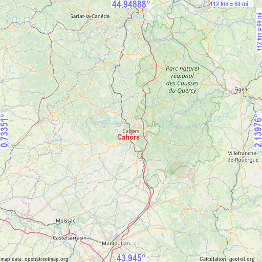
Cahors GPS coordinates[2]
44° 26' 56.76" North, 1° 26' 11.868" East
| Map corner | latitude | longitude |
|---|---|---|
| Upper-left | 44.94888°, | 0.73351° |
| Center: | 44.4491°, | 1.43663° |
| Lower-right: | 43.945°, | 2.13976° |
| Map W x H: | 111.6×111.6 km | = 69.3×69.3mi |
| max Lat: | 51.07786° ⇑83.9% North |
| Cahors: | 44.4491° |
| min Lat: | ⇓16.1% South 41.3874° |
| min Long | Cahors | max Long |
| -5.08615° | 1.43663° | 9.52242° |
| W 36.1%⇐ | ⇒63.9% E |
Elevation
Elevation of Cahors is 142 m = 466 ft, and this is 51.7 m = 170 ft below average elevation for this country.
| Max E: |
2333 m = 7654 ft | 47.2% |
| Avg. | 193.7 m = 635 ft | |
| Cahors | 142 m = 466 ft | |
Min E: |
-1 m = -3 ft | 52.8% |
See also: France elevation on elevation.city.
Geographical zone
Cahors is located in North temperate zone (between Tropic of Cancer and the Arctic Circle). Distance of this Northern Tropic circle is 2336.4 km =1451.8 mi to South.| Distance of | km | miles | from Cahors |
|---|---|---|---|
| North Pole | 5064.8 | 3147.1 | to North |
| Arctic Circle | 2458.9 | 1527.9 | to North |
| Tropic Cancer | 2336.4 | 1451.8 | to South |
| Equator | 4942.3 | 3071 | to South |


Nearby cities:
15 places around Cahors: (largest is in red/bold)
• Arcambal
6.1 km =3.8 mi,  82°
82°
• Caillac
8 km =5 mi,  304°
304°
• Catus
14.4 km =8.9 mi,  326°
326°
• Douelle
6.5 km =4 mi,  290°
290°
• Espère
8.6 km =5.3 mi,  323°
323°
• Flaujac-Poujols
7 km =4.3 mi,  134°
134°
• Labastide-Marnhac
7.4 km =4.6 mi,  203°
203°
• Lalbenque
14.9 km =9.3 mi,  144°
144°
• Lamagdelaine
4.6 km =2.9 mi,  63°
63°
• Laroque-des-Arcs
3.9 km =2.4 mi,  39°
39°
• Le Montat
7.7 km =4.8 mi,  172°
172°
• Luzech
12.3 km =7.6 mi, 285°
• Mercuès
6.7 km =4.2 mi, 323°
• Pradines
4.7 km =2.9 mi, 323°
• Trespoux-Rassiels
6.1 km =3.8 mi,  228°
228°
Sources, notices
• [Note1] Compared only with cities in France existing in our database
• [Src1] Map data: © OpenStreetMap contributors (CC-BY-SA)
• [Src2] Other city data from geonames.org with taken over terms of usage.
• [Src3] Geographical zone / Annual Mean Temperature by Robert A. Rohde @ Wikipedia
