La Guérinière geodata
La Guérinière (Pays de la Loire) is a populated place; located in France in Europe/Paris (GMT+2) time zone. With population of 1,559 people, there are 5975 cities with bigger population in this country. Compared to other cities in France, 55.7% of cities are located further ↑North; 95.6% of cities are located further →East and 99.6% of cities have higher elevation than La Guérinière. Note1
Administrative division(s):
- Level 1: Pays de la Loire
- Level 2: Département de la Vendée
- Level 3: Arrondissement des Sables-d'Olonne
- Level 4: La Guérinière


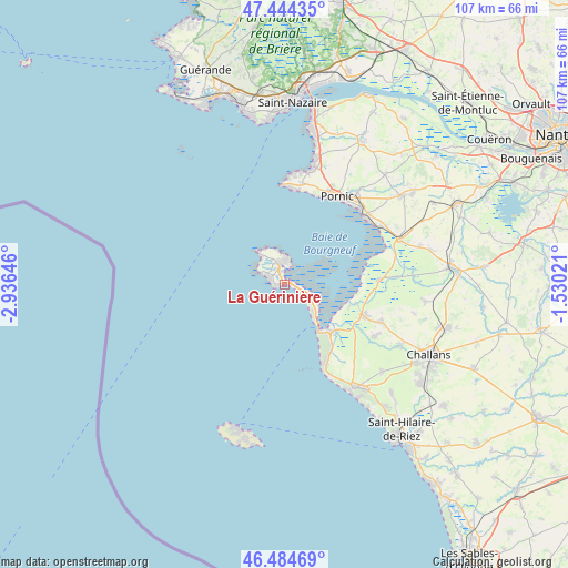
La Guérinière GPS coordinates[2]
46° 58' 0.012" North, 2° 13' 59.988" West
| Map corner | latitude | longitude |
|---|---|---|
| Upper-left | 47.44435°, | -2.93646° |
| Center: | 46.96667°, | -2.23333° |
| Lower-right: | 46.48469°, | -1.53021° |
| Map W x H: | 106.7×106.7 km | = 66.3×66.3mi |
| max Lat: | 51.07786° ⇑55.7% North |
| La Guérinière: | 46.96667° |
| min Lat: | ⇓44.3% South 41.3874° |
| min Long | La Guérinière | max Long |
| -5.08615° | -2.23333° | 9.52242° |
| W 4.4%⇐ | ⇒95.6% E |
Elevation
Elevation of La Guérinière is 4 m = 13 ft, and this is 189.7 m = 622 ft below average elevation for this country.
| Max E: |
2333 m = 7654 ft | 99.6% |
| Avg. | 193.7 m = 635 ft | |
| La Guérinière | 4 m = 13 ft | |
Min E: |
-1 m = -3 ft | 0.4% |
See also: France elevation on elevation.city.
Geographical zone
La Guérinière is located in North temperate zone (between Tropic of Cancer and the Arctic Circle). Distance of this North polar circle is 2179 km =1354 mi to North.| Distance of | km | miles | from La Guérinière |
|---|---|---|---|
| North Pole | 4784.9 | 2973.2 | to North |
| Arctic Circle | 2179 | 1354 | to North |
| Tropic Cancer | 2616.3 | 1625.7 | to South |
| Equator | 5222.2 | 3244.9 | to South |


Nearby cities:
15 places around La Guérinière: (largest is in red/bold)
• Barbâtre
5.1 km =3.2 mi,  123°
123°
• Beauvoir-sur-Mer
15.7 km =9.8 mi,  112°
112°
• Bouin
17.8 km =11.1 mi,  87°
87°
• Bourgneuf-en-Retz
23 km =14.3 mi,  68°
68°
• La Barre-de-Monts
12.8 km =8 mi,  138°
138°
• La Bernerie-en-Retz
19.6 km =12.2 mi,  49°
49°
• La Plaine-sur-Mer
19.1 km =11.9 mi,  9°
9°
• Les Moutiers-en-Retz
20.8 km =12.9 mi,  58°
58°
• Noirmoutier-en-l’Île
4.6 km =2.9 mi,  318°
318°
• Notre-Dame-de-Monts
17 km =10.6 mi,  152°
152°
• Pornic
19.5 km =12.1 mi,  34°
34°
• Préfailles
18 km =11.2 mi,  3°
3°
• Saint-Gervais
19 km =11.8 mi, 112°
• Saint-Jean-de-Monts
22.7 km =14.1 mi, 149°
• Saint-Urbain
19.8 km =12.3 mi, 120°
Sources, notices
• [Note1] Compared only with cities in France existing in our database
• [Src1] Map data: © OpenStreetMap contributors (CC-BY-SA)
• [Src2] Other city data from geonames.org with taken over terms of usage.
• [Src3] Geographical zone / Annual Mean Temperature by Robert A. Rohde @ Wikipedia
