Frangy-en-Bresse geodata
Frangy-en-Bresse (Bourgogne-Franche-Comté) is a populated place; located in France in Europe/Paris (GMT+2) time zone. With population of 578 people, there are 13683 cities with bigger population in this country. Compared to other cities in France, 57.9% of cities are located further ↑North; 80.9% of cities are located further ←West and 66.4% of cities have lower elevation than Frangy-en-Bresse. Note1
Administrative division(s):
- Level 1: Bourgogne-Franche-Comté
- Level 2: Département de Saône-et-Loire
- Level 3: Arrondissement de Louhans
- Level 4: Frangy-en-Bresse


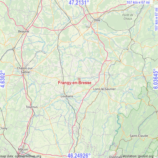
Frangy-en-Bresse GPS coordinates[2]
46° 43' 59.988" North, 5° 19' 59.988" East
| Map corner | latitude | longitude |
|---|---|---|
| Upper-left | 47.2131°, | 4.6302° |
| Center: | 46.73333°, | 5.33333° |
| Lower-right: | 46.24926°, | 6.03645° |
| Map W x H: | 107.2×107.2 km | = 66.6×66.6mi |
| max Lat: | 51.07786° ⇑57.9% North |
| Frangy-en-Bresse: | 46.73333° |
| min Lat: | ⇓42.1% South 41.3874° |
| min Long | Frangy-en-Bress | max Long |
| -5.08615° | 5.33333° | 9.52242° |
| W 80.9%⇐ | ⇒19.1% E |
Elevation
Elevation of Frangy-en-Bresse is 201 m = 659 ft, and this is 7.3 m = 24 ft above average elevation for this country.
| Max E: |
2333 m = 7654 ft | 33.6% |
| Frangy-en-Bresse | 201 m 659 ft | |
| Avg. | 193.7 m = 635 ft | |
Min E: |
-1 m = -3 ft | 66.4% |
See also: France elevation on elevation.city.
Geographical zone
Frangy-en-Bresse is located in North temperate zone (between Tropic of Cancer and the Arctic Circle). Distance of this North polar circle is 2204.9 km =1370.1 mi to North.| Distance of | km | miles | from Frangy-en-Bresse |
|---|---|---|---|
| North Pole | 4810.8 | 2989.3 | to North |
| Arctic Circle | 2204.9 | 1370.1 | to North |
| Tropic Cancer | 2590.3 | 1609.5 | to South |
| Equator | 5196.3 | 3228.8 | to South |


Nearby cities:
15 places around Frangy-en-Bresse: (largest is in red/bold)
• Beaurepaire-en-Bresse
8.3 km =5.2 mi,  149°
149°
• Bletterans
9.3 km =5.8 mi,  80°
80°
• Chapelle-Voland
8.3 km =5.2 mi,  23°
23°
• Commenailles
12 km =7.5 mi,  49°
49°
• Courlaoux
12 km =7.5 mi,  126°
126°
• La Chapelle-Saint-Sauveur
13.4 km =8.3 mi,  339°
339°
• Larnaud
9.6 km =6 mi,  104°
104°
• Le Fay
7.3 km =4.5 mi,  182°
182°
• Ruffey-sur-Seille
12.4 km =7.7 mi, 84°
• Saillenard
5.5 km =3.4 mi, 148°
• Saint-Germain-du-Bois
7.1 km =4.4 mi,  287°
287°
• Saint-Usuge
8.7 km =5.4 mi,  226°
226°
• Savigny-en-Revermont
12.7 km =7.9 mi, 148°
• Simard
11.7 km =7.3 mi,  262°
262°
• Villevieux
10 km =6.2 mi,  87°
87°
Sources, notices
• [Note1] Compared only with cities in France existing in our database
• [Src1] Map data: © OpenStreetMap contributors (CC-BY-SA)
• [Src2] Other city data from geonames.org with taken over terms of usage.
• [Src3] Geographical zone / Annual Mean Temperature by Robert A. Rohde @ Wikipedia
