Gargas geodata
Gargas (Occitanie) is a populated place; located in France in Europe/Paris (GMT+2) time zone. With population of 583 people, there are 13590 cities with bigger population in this country. Compared to other cities in France, 89.6% of cities are located further ↑North; 63.4% of cities are located further →East and 58.7% of cities have lower elevation than Gargas. Note1
Administrative division(s):
- Level 1: Occitanie
- Level 2: Haute-Garonne
- Level 3: Arrondissement de Toulouse
- Level 4: Gargas


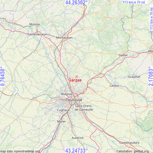
Gargas GPS coordinates[2]
43° 45' 26.388" North, 1° 28' 3.72" East
| Map corner | latitude | longitude |
|---|---|---|
| Upper-left | 44.26302°, | 0.76458° |
| Center: | 43.75733°, | 1.4677° |
| Lower-right: | 43.24733°, | 2.17083° |
| Map W x H: | 112.9×112.9 km | = 70.2×70.2mi |
| max Lat: | 51.07786° ⇑89.6% North |
| Gargas: | 43.75733° |
| min Lat: | ⇓10.4% South 41.3874° |
| min Long | Gargas | max Long |
| -5.08615° | 1.4677° | 9.52242° |
| W 36.6%⇐ | ⇒63.4% E |
Elevation
Elevation of Gargas is 164 m = 538 ft, and this is 29.7 m = 97 ft below average elevation for this country.
| Max E: |
2333 m = 7654 ft | 41.3% |
| Avg. | 193.7 m = 635 ft | |
| Gargas | 164 m = 538 ft | |
Min E: |
-1 m = -3 ft | 58.7% |
See also: France elevation on elevation.city.
Geographical zone
Gargas is located in North temperate zone (between Tropic of Cancer and the Arctic Circle). Distance of this Northern Tropic circle is 2259.4 km =1403.9 mi to South.| Distance of | km | miles | from Gargas |
|---|---|---|---|
| North Pole | 5141.7 | 3194.9 | to North |
| Arctic Circle | 2535.8 | 1575.7 | to North |
| Tropic Cancer | 2259.4 | 1403.9 | to South |
| Equator | 4865.4 | 3023.2 | to South |


Nearby cities:
15 places around Gargas: (largest is in red/bold)
• Bazus
4.6 km =2.9 mi,  122°
122°
• Bouloc
5.7 km =3.5 mi,  298°
298°
• Bruguières
5.9 km =3.7 mi,  235°
235°
• Cépet
3 km =1.9 mi,  251°
251°
• Gratentour
4.7 km =2.9 mi,  217°
217°
• Labastide-Saint-Sernin
2.2 km =1.4 mi,  175°
175°
• Montberon
4.7 km =2.9 mi,  168°
168°
• Montjoire
5.4 km =3.4 mi,  76°
76°
• Paulhac
7.1 km =4.4 mi,  90°
90°
• Pechbonnieu
6.1 km =3.8 mi, 181°
• Saint-Loup-Cammas
6.7 km =4.2 mi, 170°
• Saint-Sauveur
5.5 km =3.4 mi,  259°
259°
• Vacquiers
2.4 km =1.5 mi,  26°
26°
• Villariès
2 km =1.2 mi,  111°
111°
• Villeneuve-lès-Bouloc
3.8 km =2.4 mi,  287°
287°
Sources, notices
• [Note1] Compared only with cities in France existing in our database
• [Src1] Map data: © OpenStreetMap contributors (CC-BY-SA)
• [Src2] Other city data from geonames.org with taken over terms of usage.
• [Src3] Geographical zone / Annual Mean Temperature by Robert A. Rohde @ Wikipedia
