Cercier geodata
Cercier (Auvergne-Rhône-Alpes) is a populated place; located in France in Europe/Paris (GMT+2) time zone. With population of 571 people, there are 13815 cities with bigger population in this country. Compared to other cities in France, 66% of cities are located further ↑North; 87.6% of cities are located further ←West and 94.2% of cities have lower elevation than Cercier. Note1
Administrative division(s):
- Level 1: Auvergne-Rhône-Alpes
- Level 2: Haute-Savoie
- Level 3: Arrondissement de Saint-Julien-en-Genevois
- Level 4: Cercier


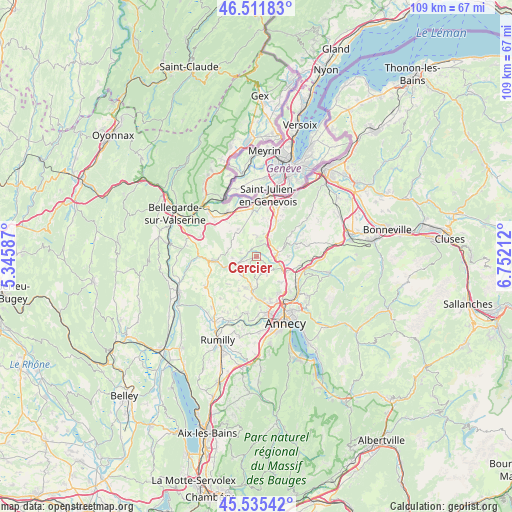
Cercier GPS coordinates[2]
46° 1' 32.808" North, 6° 2' 56.364" East
| Map corner | latitude | longitude |
|---|---|---|
| Upper-left | 46.51183°, | 5.34587° |
| Center: | 46.02578°, | 6.04899° |
| Lower-right: | 45.53542°, | 6.75212° |
| Map W x H: | 108.6×108.6 km | = 67.5×67.5mi |
| max Lat: | 51.07786° ⇑66% North |
| Cercier: | 46.02578° |
| min Lat: | ⇓34% South 41.3874° |
| min Long | Cercier | max Long |
| -5.08615° | 6.04899° | 9.52242° |
| W 87.6%⇐ | ⇒12.4% E |
Elevation
Elevation of Cercier is 550 m = 1804 ft, and this is 356.3 m = 1169 ft above average elevation for this country.
| Max E: |
2333 m = 7654 ft | 5.8% |
| Cercier | 550 m 1804 ft | |
| Avg. | 193.7 m = 635 ft | |
Min E: |
-1 m = -3 ft | 94.2% |
See also: France elevation on elevation.city.
Geographical zone
Cercier is located in North temperate zone (between Tropic of Cancer and the Arctic Circle). Distance of this North polar circle is 2283.6 km =1419 mi to North.| Distance of | km | miles | from Cercier |
|---|---|---|---|
| North Pole | 4889.5 | 3038.2 | to North |
| Arctic Circle | 2283.6 | 1419 | to North |
| Tropic Cancer | 2511.7 | 1560.7 | to South |
| Equator | 5117.6 | 3179.9 | to South |


Nearby cities:
15 places around Cercier: (largest is in red/bold)
• Allonzier-la-Caille
6 km =3.7 mi,  116°
116°
• Andilly
3.8 km =2.4 mi,  19°
19°
• Cernex
4.1 km =2.5 mi,  0°
0°
• Chilly
8.2 km =5.1 mi,  242°
242°
• Choisy
3.7 km =2.3 mi,  168°
168°
• Copponex
3.3 km =2.1 mi,  33°
33°
• Cruseilles
4.6 km =2.9 mi,  84°
84°
• Cuvat
7.7 km =4.8 mi,  135°
135°
• Jonzier
6.7 km =4.2 mi,  318°
318°
• La Balme-de-Sillingy
6.3 km =3.9 mi,  184°
184°
• Minzier
5.5 km =3.4 mi,  300°
300°
• Mésigny
5.3 km =3.3 mi,  220°
220°
• Présilly
7.8 km =4.8 mi, 16°
• Sallenôves
4.6 km =2.9 mi, 240°
• Vers
7.2 km =4.5 mi,  349°
349°
Sources, notices
• [Note1] Compared only with cities in France existing in our database
• [Src1] Map data: © OpenStreetMap contributors (CC-BY-SA)
• [Src2] Other city data from geonames.org with taken over terms of usage.
• [Src3] Geographical zone / Annual Mean Temperature by Robert A. Rohde @ Wikipedia
