Kutzenhausen geodata
Kutzenhausen (Grand Est) is a populated place; located in France in Europe/Paris (GMT+2) time zone. With population of 836 people, there are 10228 cities with bigger population in this country. Compared to other cities in France, 78.2% of cities are located further ↓South; 99.3% of cities are located further ←West and 57.6% of cities have lower elevation than Kutzenhausen. Note1
Administrative division(s):
- Level 1: Grand Est
- Level 2: Bas-Rhin
- Level 3: Arrondissement de Haguenau-Wissembourg
- Level 4: Kutzenhausen


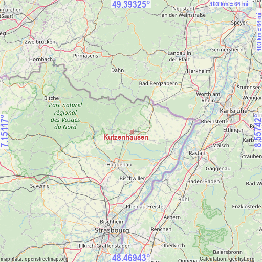
Kutzenhausen GPS coordinates[2]
48° 56' 0.528" North, 7° 51' 15.48" East
| Map corner | latitude | longitude |
|---|---|---|
| Upper-left | 49.39325°, | 7.15117° |
| Center: | 48.93348°, | 7.8543° |
| Lower-right: | 48.46943°, | 8.55742° |
| Map W x H: | 102.7×102.7 km | = 63.8×63.8mi |
| max Lat: | 51.07786° ⇑21.8% North |
| Kutzenhausen: | 48.93348° |
| min Lat: | ⇓78.2% South 41.3874° |
| min Long | Kutzenhausen | max Long |
| -5.08615° | 7.8543° | 9.52242° |
| W 99.3%⇐ | ⇒0.7% E |
Elevation
Elevation of Kutzenhausen is 160 m = 525 ft, and this is 33.7 m = 111 ft below average elevation for this country.
| Max E: |
2333 m = 7654 ft | 42.4% |
| Avg. | 193.7 m = 635 ft | |
| Kutzenhausen | 160 m = 525 ft | |
Min E: |
-1 m = -3 ft | 57.6% |
See also: France elevation on elevation.city.
Geographical zone
Kutzenhausen is located in North temperate zone (between Tropic of Cancer and the Arctic Circle). Distance of this North polar circle is 1960.3 km =1218.1 mi to North.| Distance of | km | miles | from Kutzenhausen |
|---|---|---|---|
| North Pole | 4566.2 | 2837.3 | to North |
| Arctic Circle | 1960.3 | 1218.1 | to North |
| Tropic Cancer | 2835 | 1761.6 | to South |
| Equator | 5440.9 | 3380.8 | to South |


Nearby cities:
15 places around Kutzenhausen: (largest is in red/bold)
• Betschdorf
5.2 km =3.2 mi,  138°
138°
• Birlenbach
5.2 km =3.2 mi,  21°
21°
• Durrenbach
7.5 km =4.7 mi,  237°
237°
• Gunstett
7 km =4.3 mi,  252°
252°
• Gœrsdorf
6.7 km =4.2 mi,  286°
286°
• Lampertsloch
3.9 km =2.4 mi,  313°
313°
• Lembach
9.1 km =5.7 mi,  328°
328°
• Lobsann
3.4 km =2.1 mi,  348°
348°
• Merkwiller-Pechelbronn
1.9 km =1.2 mi,  283°
283°
• Morsbronn-les-Bains
8.8 km =5.5 mi, 246°
• Preuschdorf
4.1 km =2.5 mi, 287°
• Soultz-sous-Forêts
2 km =1.2 mi,  78°
78°
• Surbourg
2.7 km =1.7 mi,  191°
191°
• Walbourg
7.1 km =4.4 mi,  222°
222°
• Woerth
8.2 km =5.1 mi,  274°
274°
Sources, notices
• [Note1] Compared only with cities in France existing in our database
• [Src1] Map data: © OpenStreetMap contributors (CC-BY-SA)
• [Src2] Other city data from geonames.org with taken over terms of usage.
• [Src3] Geographical zone / Annual Mean Temperature by Robert A. Rohde @ Wikipedia
