Kergrist-Moëlou geodata
Kergrist-Moëlou (Brittany) is a populated place; located in France in Europe/Paris (GMT+2) time zone. With population of 727 people, there are 11442 cities with bigger population in this country. Compared to other cities in France, 64.7% of cities are located further ↓South; 98% of cities are located further →East and 77.4% of cities have lower elevation than Kergrist-Moëlou. Note1
Administrative division(s):
- Level 1: Brittany
- Level 2: Département des Côtes-d’Armor
- Level 3: Arrondissement de Guingamp
- Level 4: Kergrist-Moëlou


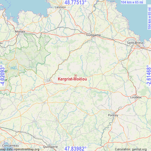
Kergrist-Moëlou GPS coordinates[2]
48° 18' 34.632" North, 3° 19' 4.08" West
| Map corner | latitude | longitude |
|---|---|---|
| Upper-left | 48.77513°, | -4.02093° |
| Center: | 48.30962°, | -3.3178° |
| Lower-right: | 47.83982°, | -2.61468° |
| Map W x H: | 104×104 km | = 64.6×64.6mi |
| max Lat: | 51.07786° ⇑35.3% North |
| Kergrist-Moëlou: | 48.30962° |
| min Lat: | ⇓64.7% South 41.3874° |
| min Long | Kergrist-Moëlo | max Long |
| -5.08615° | -3.3178° | 9.52242° |
| W 2%⇐ | ⇒98% E |
Elevation
Elevation of Kergrist-Moëlou is 267 m = 876 ft, and this is 73.3 m = 240 ft above average elevation for this country.
| Max E: |
2333 m = 7654 ft | 22.6% |
| Kergrist-Moëlou | 267 m 876 ft | |
| Avg. | 193.7 m = 635 ft | |
Min E: |
-1 m = -3 ft | 77.4% |
See also: France elevation on elevation.city.
Geographical zone
Kergrist-Moëlou is located in North temperate zone (between Tropic of Cancer and the Arctic Circle). Distance of this North polar circle is 2029.6 km =1261.1 mi to North.| Distance of | km | miles | from Kergrist-Moëlou |
|---|---|---|---|
| North Pole | 4635.5 | 2880.4 | to North |
| Arctic Circle | 2029.6 | 1261.1 | to North |
| Tropic Cancer | 2765.6 | 1718.5 | to South |
| Equator | 5371.5 | 3337.7 | to South |


Nearby cities:
15 places around Kergrist-Moëlou: (largest is in red/bold)
• Callac
13.2 km =8.2 mi,  321°
321°
• Glomel
11.3 km =7 mi,  211°
211°
• Gouarec
13.7 km =8.5 mi,  131°
131°
• Lanrivain
8.7 km =5.4 mi,  61°
61°
• Le Moustoir
14.7 km =9.1 mi,  251°
251°
• Maël-Carhaix
8.3 km =5.2 mi, 250°
• Paule
12.4 km =7.7 mi,  228°
228°
• Plouguernével
9.3 km =5.8 mi,  147°
147°
• Plounévez-Quintin
6.9 km =4.3 mi,  115°
115°
• Plusquellec
14.7 km =9.1 mi,  303°
303°
• Plélauff
14.1 km =8.8 mi,  144°
144°
• Rostrenen
8.1 km =5 mi,  178°
178°
• Saint-Nicolas-du-Pélem
11.3 km =7 mi,  88°
88°
• Treffrin
14.7 km =9.1 mi,  265°
265°
• Trébrivan
12.3 km =7.6 mi, 273°
Sources, notices
• [Note1] Compared only with cities in France existing in our database
• [Src1] Map data: © OpenStreetMap contributors (CC-BY-SA)
• [Src2] Other city data from geonames.org with taken over terms of usage.
• [Src3] Geographical zone / Annual Mean Temperature by Robert A. Rohde @ Wikipedia
