Kaysersberg geodata
Kaysersberg (Grand Est) is a populated place; located in France in Europe/Paris (GMT+2) time zone. With population of 2,815 people, there are 3462 cities with bigger population in this country. Compared to other cities in France, 61.8% of cities are located further ↓South; 96.2% of cities are located further ←West and 75.3% of cities have lower elevation than Kaysersberg. Note1
Administrative division(s):
- Level 1: Grand Est
- Level 2: Haut-Rhin
- Level 3: Arrondissement de Colmar-Ribeauvillé
- Level 4: Kaysersberg Vignoble


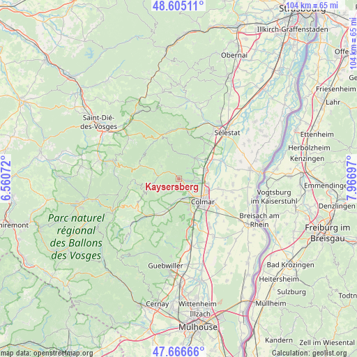
Kaysersberg GPS coordinates[2]
48° 8' 16.908" North, 7° 15' 49.86" East
| Map corner | latitude | longitude |
|---|---|---|
| Upper-left | 48.60511°, | 6.56072° |
| Center: | 48.13803°, | 7.26385° |
| Lower-right: | 47.66666°, | 7.96697° |
| Map W x H: | 104.3×104.3 km | = 64.8×64.8mi |
| max Lat: | 51.07786° ⇑38.2% North |
| Kaysersberg: | 48.13803° |
| min Lat: | ⇓61.8% South 41.3874° |
| min Long | Kaysersberg | max Long |
| -5.08615° | 7.26385° | 9.52242° |
| W 96.2%⇐ | ⇒3.8% E |
Elevation
Elevation of Kaysersberg is 251 m = 823 ft, and this is 57.3 m = 188 ft above average elevation for this country.
| Max E: |
2333 m = 7654 ft | 24.7% |
| Kaysersberg | 251 m 823 ft | |
| Avg. | 193.7 m = 635 ft | |
Min E: |
-1 m = -3 ft | 75.3% |
See also: France elevation on elevation.city.
Geographical zone
Kaysersberg is located in North temperate zone (between Tropic of Cancer and the Arctic Circle). Distance of this North polar circle is 2048.7 km =1273 mi to North.| Distance of | km | miles | from Kaysersberg |
|---|---|---|---|
| North Pole | 4654.6 | 2892.2 | to North |
| Arctic Circle | 2048.7 | 1273 | to North |
| Tropic Cancer | 2746.5 | 1706.6 | to South |
| Equator | 5352.4 | 3325.8 | to South |


Nearby cities:
15 places around Kaysersberg: (largest is in red/bold)
• Ammerschwihr
2 km =1.2 mi,  134°
134°
• Beblenheim
5.2 km =3.2 mi,  65°
65°
• Bennwihr
4.6 km =2.9 mi,  80°
80°
• Fréland
6.6 km =4.1 mi,  305°
305°
• Hunawihr
5.9 km =3.7 mi,  36°
36°
• Ingersheim
5.3 km =3.3 mi,  146°
146°
• Katzenthal
3.6 km =2.2 mi,  158°
158°
• Kientzheim
1.7 km =1.1 mi,  97°
97°
• Labaroche
6.1 km =3.8 mi,  240°
240°
• Lapoutroie
7.4 km =4.6 mi,  283°
283°
• Mittelwihr
4.3 km =2.7 mi, 70°
• Niedermorschwihr
4.3 km =2.7 mi,  170°
170°
• Riquewihr
4 km =2.5 mi, 37°
• Sigolsheim
2.7 km =1.7 mi, 97°
• Turckheim
5.7 km =3.5 mi, 170°
Sources, notices
• [Note1] Compared only with cities in France existing in our database
• [Src1] Map data: © OpenStreetMap contributors (CC-BY-SA)
• [Src2] Other city data from geonames.org with taken over terms of usage.
• [Src3] Geographical zone / Annual Mean Temperature by Robert A. Rohde @ Wikipedia
