Anthon geodata
Anthon (Auvergne-Rhône-Alpes) is a populated place; located in France in Europe/Paris (GMT+2) time zone. With population of 993 people, there are 8879 cities with bigger population in this country. Compared to other cities in France, 69.4% of cities are located further ↑North; 79.4% of cities are located further ←West and 69% of cities have lower elevation than Anthon. Note1
Administrative division(s):
- Level 1: Auvergne-Rhône-Alpes
- Level 2: Département de l'Isère
- Level 3: Arrondissement de La Tour-du-Pin
- Level 4: Anthon


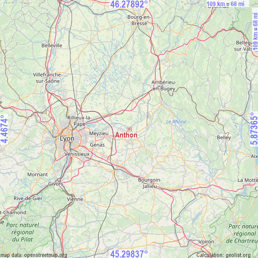
Anthon GPS coordinates[2]
45° 47' 26.88" North, 5° 10' 13.872" East
| Map corner | latitude | longitude |
|---|---|---|
| Upper-left | 46.27892°, | 4.4674° |
| Center: | 45.7908°, | 5.17052° |
| Lower-right: | 45.29837°, | 5.87365° |
| Map W x H: | 109×109 km | = 67.7×67.7mi |
| max Lat: | 51.07786° ⇑69.4% North |
| Anthon: | 45.7908° |
| min Lat: | ⇓30.6% South 41.3874° |
| min Long | Anthon | max Long |
| -5.08615° | 5.17052° | 9.52242° |
| W 79.4%⇐ | ⇒20.6% E |
Elevation
Elevation of Anthon is 214 m = 702 ft, and this is 20.3 m = 67 ft above average elevation for this country.
| Max E: |
2333 m = 7654 ft | 31% |
| Anthon | 214 m 702 ft | |
| Avg. | 193.7 m = 635 ft | |
Min E: |
-1 m = -3 ft | 69% |
See also: France elevation on elevation.city.
Geographical zone
Anthon is located in North temperate zone (between Tropic of Cancer and the Arctic Circle). Distance of this North polar circle is 2309.7 km =1435.2 mi to North.| Distance of | km | miles | from Anthon |
|---|---|---|---|
| North Pole | 4915.6 | 3054.4 | to North |
| Arctic Circle | 2309.7 | 1435.2 | to North |
| Tropic Cancer | 2485.5 | 1544.4 | to South |
| Equator | 5091.5 | 3163.7 | to South |


Nearby cities:
15 places around Anthon: (largest is in red/bold)
• Balan
7.3 km =4.5 mi,  311°
311°
• Blyes
9 km =5.6 mi,  44°
44°
• Charvieu-Chavagneux
4.8 km =3 mi,  199°
199°
• Chavanoz
2.8 km =1.7 mi,  151°
151°
• Janneyrias
6.2 km =3.9 mi,  226°
226°
• Jons
7.2 km =4.5 mi,  285°
285°
• Leyrieu
7.5 km =4.7 mi,  117°
117°
• Loyettes
3.2 km =2 mi, 119°
• Pont-de-Chéruy
4.2 km =2.6 mi,  177°
177°
• Pusignan
8.9 km =5.5 mi,  243°
243°
• Saint-Jean-de-Niost
5.9 km =3.7 mi, 37°
• Saint-Maurice-de-Gourdans
4 km =2.5 mi,  27°
27°
• Saint-Romain-de-Jalionas
5.2 km =3.2 mi,  136°
136°
• Tignieu
4.6 km =2.9 mi,  161°
161°
• Villemoirieu
9.1 km =5.7 mi, 151°
Sources, notices
• [Note1] Compared only with cities in France existing in our database
• [Src1] Map data: © OpenStreetMap contributors (CC-BY-SA)
• [Src2] Other city data from geonames.org with taken over terms of usage.
• [Src3] Geographical zone / Annual Mean Temperature by Robert A. Rohde @ Wikipedia
