Ille-sur-Têt geodata
Ille-sur-Têt (Occitanie) is a populated place; located in France in Europe/Paris (GMT+2) time zone. With population of 5,470 people, there are 1806 cities with bigger population in this country. Compared to other cities in France, 99.1% of cities are located further ↑North; 52.4% of cities are located further ←West and 56.1% of cities have lower elevation than Ille-sur-Têt. Note1
Administrative division(s):
- Level 1: Occitanie
- Level 2: Département des Pyrénées-Orientales
- Level 3: Arrondissement de Prades
- Level 4: Ille-sur-Têt


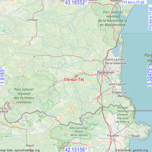
Ille-sur-Têt GPS coordinates[2]
42° 40' 14.484" North, 2° 37' 17.832" East
| Map corner | latitude | longitude |
|---|---|---|
| Upper-left | 43.18552°, | 1.9185° |
| Center: | 42.67069°, | 2.62162° |
| Lower-right: | 42.15156°, | 3.32475° |
| Map W x H: | 115×115 km | = 71.5×71.5mi |
| max Lat: | 51.07786° ⇑99.1% North |
| Ille-sur-Têt: | 42.67069° |
| min Lat: | ⇓0.9% South 41.3874° |
| min Long | Ille-sur-Têt | max Long |
| -5.08615° | 2.62162° | 9.52242° |
| W 52.4%⇐ | ⇒47.6% E |
Elevation
Elevation of Ille-sur-Têt is 154 m = 505 ft, and this is 39.7 m = 130 ft below average elevation for this country.
| Max E: |
2333 m = 7654 ft | 43.9% |
| Avg. | 193.7 m = 635 ft | |
| Ille-sur-Têt | 154 m = 505 ft | |
Min E: |
-1 m = -3 ft | 56.1% |
See also: France elevation on elevation.city.
Geographical zone
Ille-sur-Têt is located in North temperate zone (between Tropic of Cancer and the Arctic Circle). Distance of this Northern Tropic circle is 2138.6 km =1328.9 mi to South.| Distance of | km | miles | from Ille-sur-Têt |
|---|---|---|---|
| North Pole | 5262.5 | 3270 | to North |
| Arctic Circle | 2656.6 | 1650.7 | to North |
| Tropic Cancer | 2138.6 | 1328.9 | to South |
| Equator | 4744.5 | 2948.1 | to South |


Nearby cities:
15 places around Ille-sur-Têt: (largest is in red/bold)
• Bouleternère
3.8 km =2.4 mi,  231°
231°
• Corbère
3.7 km =2.3 mi,  121°
121°
• Corbère-les-Cabanes
4.6 km =2.9 mi,  108°
108°
• Corneilla-la-Rivière
9.3 km =5.8 mi,  71°
71°
• Estagel
12.9 km =8 mi,  28°
28°
• Latour-de-France
11.1 km =6.9 mi,  13°
13°
• Marquixanes
11.8 km =7.3 mi,  253°
253°
• Millas
6.5 km =4 mi, 68°
• Néfiach
4.5 km =2.8 mi,  55°
55°
• Pézilla-la-Rivière
12.5 km =7.8 mi,  77°
77°
• Rodès
5.1 km =3.2 mi, 252°
• Saint-Féliu-d’Amont
8.5 km =5.3 mi, 77°
• Saint-Féliu-d’Avall
9.6 km =6 mi, 83°
• Thuir
11.7 km =7.3 mi, 111°
• Vinça
8.2 km =5.1 mi, 249°
Sources, notices
• [Note1] Compared only with cities in France existing in our database
• [Src1] Map data: © OpenStreetMap contributors (CC-BY-SA)
• [Src2] Other city data from geonames.org with taken over terms of usage.
• [Src3] Geographical zone / Annual Mean Temperature by Robert A. Rohde @ Wikipedia
