Latour-de-France geodata
Latour-de-France (Occitanie) is a populated place; located in France in Europe/Paris (GMT+2) time zone. With population of 964 people, there are 9100 cities with bigger population in this country. Compared to other cities in France, 98.9% of cities are located further ↑North; 52.8% of cities are located further ←West and 56.2% of cities have higher elevation than Latour-de-France. Note1
Administrative division(s):
- Level 1: Occitanie
- Level 2: Département des Pyrénées-Orientales
- Level 3: Arrondissement de Prades
- Level 4: Latour-de-France


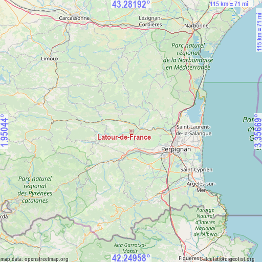
Latour-de-France GPS coordinates[2]
42° 46' 4.44" North, 2° 39' 12.816" East
| Map corner | latitude | longitude |
|---|---|---|
| Upper-left | 43.28192°, | 1.95044° |
| Center: | 42.7679°, | 2.65356° |
| Lower-right: | 42.24958°, | 3.35669° |
| Map W x H: | 114.8×114.8 km | = 71.3×71.3mi |
| max Lat: | 51.07786° ⇑98.9% North |
| Latour-de-France: | 42.7679° |
| min Lat: | ⇓1.1% South 41.3874° |
| min Long | Latour-de-Franc | max Long |
| -5.08615° | 2.65356° | 9.52242° |
| W 52.8%⇐ | ⇒47.2% E |
Elevation
Elevation of Latour-de-France is 113 m = 371 ft, and this is 80.7 m = 265 ft below average elevation for this country.
| Max E: |
2333 m = 7654 ft | 56.2% |
| Avg. | 193.7 m = 635 ft | |
| Latour-de-France | 113 m = 371 ft | |
Min E: |
-1 m = -3 ft | 43.8% |
See also: France elevation on elevation.city.
Geographical zone
Latour-de-France is located in North temperate zone (between Tropic of Cancer and the Arctic Circle). Distance of this Northern Tropic circle is 2149.4 km =1335.6 mi to South.| Distance of | km | miles | from Latour-de-France |
|---|---|---|---|
| North Pole | 5251.7 | 3263.3 | to North |
| Arctic Circle | 2645.8 | 1644 | to North |
| Tropic Cancer | 2149.4 | 1335.6 | to South |
| Equator | 4755.3 | 2954.8 | to South |


Nearby cities:
15 places around Latour-de-France: (largest is in red/bold)
• Baixas
12.9 km =8 mi,  99°
99°
• Cases-de-Pène
10.9 km =6.8 mi,  83°
83°
• Corbère
12.8 km =8 mi,  177°
177°
• Corbère-les-Cabanes
12.4 km =7.7 mi,  171°
171°
• Corneilla-la-Rivière
10.1 km =6.3 mi,  141°
141°
• Estagel
3.6 km =2.2 mi, 80°
• Ille-sur-Têt
11.1 km =6.9 mi,  193°
193°
• Maury
6.8 km =4.2 mi,  314°
314°
• Millas
9.1 km =5.7 mi,  158°
158°
• Néfiach
8.3 km =5.2 mi, 172°
• Paziols
11.4 km =7.1 mi,  28°
28°
• Pézilla-la-Rivière
12.5 km =7.8 mi,  130°
130°
• Saint-Féliu-d’Amont
10.7 km =6.6 mi,  147°
147°
• Saint-Féliu-d’Avall
11.9 km =7.4 mi, 144°
• Tautavel
9.2 km =5.7 mi,  55°
55°
Sources, notices
• [Note1] Compared only with cities in France existing in our database
• [Src1] Map data: © OpenStreetMap contributors (CC-BY-SA)
• [Src2] Other city data from geonames.org with taken over terms of usage.
• [Src3] Geographical zone / Annual Mean Temperature by Robert A. Rohde @ Wikipedia
