Blangy-sur-Ternoise geodata
Blangy-sur-Ternoise (Hauts-de-France) is a populated place; located in France in Europe/Paris (GMT+2) time zone. With population of 761 people, there are 11045 cities with bigger population in this country. Compared to other cities in France, 96.7% of cities are located further ↓South; 54.9% of cities are located further →East and 82.2% of cities have higher elevation than Blangy-sur-Ternoise. Note1
Administrative division(s):
- Level 1: Hauts-de-France
- Level 2: Pas-de-Calais
- Level 3: Arrondissement de Montreuil
- Level 4: Blangy-sur-Ternoise


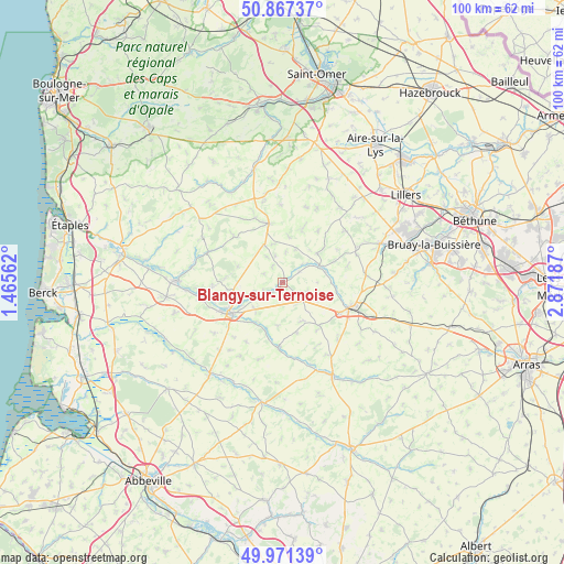
Blangy-sur-Ternoise GPS coordinates[2]
50° 25' 17.4" North, 2° 10' 7.464" East
| Map corner | latitude | longitude |
|---|---|---|
| Upper-left | 50.86737°, | 1.46562° |
| Center: | 50.4215°, | 2.16874° |
| Lower-right: | 49.97139°, | 2.87187° |
| Map W x H: | 99.6×99.6 km | = 61.9×61.9mi |
| max Lat: | 51.07786° ⇑3.3% North |
| Blangy-sur-Ternoise: | 50.4215° |
| min Lat: | ⇓96.7% South 41.3874° |
| min Long | Blangy-sur-Tern | max Long |
| -5.08615° | 2.16874° | 9.52242° |
| W 45.1%⇐ | ⇒54.9% E |
Elevation
Elevation of Blangy-sur-Ternoise is 49 m = 161 ft, and this is 144.7 m = 475 ft below average elevation for this country.
| Max E: |
2333 m = 7654 ft | 82.2% |
| Avg. | 193.7 m = 635 ft | |
| Blangy-sur-Ternoise | 49 m = 161 ft | |
Min E: |
-1 m = -3 ft | 17.8% |
See also: France elevation on elevation.city.
Geographical zone
Blangy-sur-Ternoise is located in North temperate zone (between Tropic of Cancer and the Arctic Circle). Distance of this North polar circle is 1794.8 km =1115.2 mi to North.| Distance of | km | miles | from Blangy-sur-Ternoise |
|---|---|---|---|
| North Pole | 4400.7 | 2734.5 | to North |
| Arctic Circle | 1794.8 | 1115.2 | to North |
| Tropic Cancer | 3000.4 | 1864.4 | to South |
| Equator | 5606.3 | 3483.6 | to South |


Nearby cities:
15 places around Blangy-sur-Ternoise: (largest is in red/bold)
• Anvin
6.6 km =4.1 mi,  65°
65°
• Auchy-lès-Hesdin
5.3 km =3.3 mi,  244°
244°
• Coupelle-Vieille
12.4 km =7.7 mi,  336°
336°
• Créquy
11.4 km =7.1 mi,  314°
314°
• Fillièvres
11.7 km =7.3 mi,  183°
183°
• Fressin
9 km =5.6 mi,  290°
290°
• Fruges
10.7 km =6.6 mi,  346°
346°
• Gauchin-Verloingt
10.5 km =6.5 mi,  105°
105°
• Hesdin
10.7 km =6.6 mi, 240°
• Heuchin
9.3 km =5.8 mi,  49°
49°
• Huby-Saint-Leu
10.3 km =6.4 mi, 244°
• Le Parcq
6.9 km =4.3 mi,  226°
226°
• Lisbourg
10.1 km =6.3 mi,  19°
19°
• Marconne
10.3 km =6.4 mi, 237°
• Marconnelle
12.3 km =7.6 mi,  245°
245°
Sources, notices
• [Note1] Compared only with cities in France existing in our database
• [Src1] Map data: © OpenStreetMap contributors (CC-BY-SA)
• [Src2] Other city data from geonames.org with taken over terms of usage.
• [Src3] Geographical zone / Annual Mean Temperature by Robert A. Rohde @ Wikipedia
