Houdan geodata
Houdan (Île-de-France) is a populated place; located in France in Europe/Paris (GMT+2) time zone. With population of 3,150 people, there are 3090 cities with bigger population in this country. Compared to other cities in France, 75.3% of cities are located further ↓South; 61.7% of cities are located further →East and 57.9% of cities have higher elevation than Houdan. Note1
Administrative division(s):
- Level 1: Île-de-France
- Level 2: Yvelines
- Level 3: Arrondissement de Mantes-la-Jolie
- Level 4: Houdan


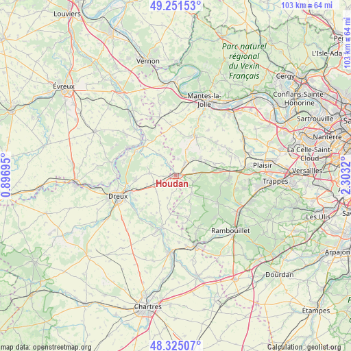
Houdan GPS coordinates[2]
48° 47' 25.584" North, 1° 36' 0.252" East
| Map corner | latitude | longitude |
|---|---|---|
| Upper-left | 49.25153°, | 0.89695° |
| Center: | 48.79044°, | 1.60007° |
| Lower-right: | 48.32507°, | 2.3032° |
| Map W x H: | 103×103 km | = 64×64mi |
| max Lat: | 51.07786° ⇑24.7% North |
| Houdan: | 48.79044° |
| min Lat: | ⇓75.3% South 41.3874° |
| min Long | Houdan | max Long |
| -5.08615° | 1.60007° | 9.52242° |
| W 38.3%⇐ | ⇒61.7% E |
Elevation
Elevation of Houdan is 108 m = 354 ft, and this is 85.7 m = 281 ft below average elevation for this country.
| Max E: |
2333 m = 7654 ft | 57.9% |
| Avg. | 193.7 m = 635 ft | |
| Houdan | 108 m = 354 ft | |
Min E: |
-1 m = -3 ft | 42.1% |
See also: France elevation on elevation.city.
Geographical zone
Houdan is located in North temperate zone (between Tropic of Cancer and the Arctic Circle). Distance of this North polar circle is 1976.2 km =1228 mi to North.| Distance of | km | miles | from Houdan |
|---|---|---|---|
| North Pole | 4582.1 | 2847.2 | to North |
| Arctic Circle | 1976.2 | 1228 | to North |
| Tropic Cancer | 2819.1 | 1751.7 | to South |
| Equator | 5425 | 3370.9 | to South |


Nearby cities:
15 places around Houdan: (largest is in red/bold)
• Abondant
11.7 km =7.3 mi,  267°
267°
• Adainville
8.4 km =5.2 mi,  152°
152°
• Bazainville
5.2 km =3.2 mi,  72°
72°
• Berchères-sur-Vesgre
7.1 km =4.4 mi,  324°
324°
• Broué
7.3 km =4.5 mi,  230°
230°
• Bû
7.6 km =4.7 mi,  275°
275°
• Condé-sur-Vesgre
7 km =4.3 mi,  140°
140°
• Gambais
5.6 km =3.5 mi,  109°
109°
• Goussainville
3.6 km =2.2 mi,  244°
244°
• Maulette
1.6 km =1 mi,  80°
80°
• Orgerus
9.1 km =5.7 mi,  54°
54°
• Perdreauville
6 km =3.7 mi, 83°
• Rouvres
10 km =6.2 mi,  303°
303°
• Saint-Lubin-de-la-Haye
3.8 km =2.4 mi,  327°
327°
• Tacoignières
7.5 km =4.7 mi, 47°
Sources, notices
• [Note1] Compared only with cities in France existing in our database
• [Src1] Map data: © OpenStreetMap contributors (CC-BY-SA)
• [Src2] Other city data from geonames.org with taken over terms of usage.
• [Src3] Geographical zone / Annual Mean Temperature by Robert A. Rohde @ Wikipedia
