Goussainville geodata
Goussainville (Centre) is a populated place; located in France in Europe/Paris (GMT+2) time zone. With population of 758 people, there are 11078 cities with bigger population in this country. Compared to other cities in France, 75% of cities are located further ↓South; 62.3% of cities are located further →East and 50.5% of cities have higher elevation than Goussainville. Note1
Administrative division(s):
- Level 1: Centre
- Level 2: Département d'Eure-et-Loir
- Level 3: Arrondissement de Dreux
- Level 4: Goussainville


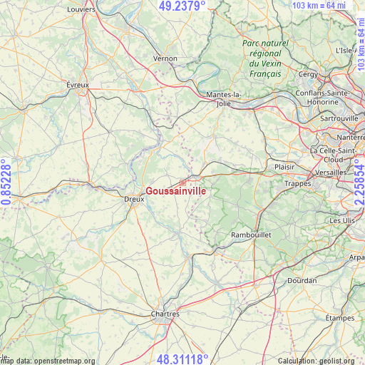
Goussainville GPS coordinates[2]
48° 46' 36.048" North, 1° 33' 19.476" East
| Map corner | latitude | longitude |
|---|---|---|
| Upper-left | 49.2379°, | 0.85228° |
| Center: | 48.77668°, | 1.55541° |
| Lower-right: | 48.31118°, | 2.25854° |
| Map W x H: | 103×103 km | = 64×64mi |
| max Lat: | 51.07786° ⇑25% North |
| Goussainville: | 48.77668° |
| min Lat: | ⇓75% South 41.3874° |
| min Long | Goussainville | max Long |
| -5.08615° | 1.55541° | 9.52242° |
| W 37.7%⇐ | ⇒62.3% E |
Elevation
Elevation of Goussainville is 130 m = 427 ft, and this is 63.7 m = 209 ft below average elevation for this country.
| Max E: |
2333 m = 7654 ft | 50.5% |
| Avg. | 193.7 m = 635 ft | |
| Goussainville | 130 m = 427 ft | |
Min E: |
-1 m = -3 ft | 49.5% |
See also: France elevation on elevation.city.
Geographical zone
Goussainville is located in North temperate zone (between Tropic of Cancer and the Arctic Circle). Distance of this North polar circle is 1977.7 km =1228.9 mi to North.| Distance of | km | miles | from Goussainville |
|---|---|---|---|
| North Pole | 4583.6 | 2848.1 | to North |
| Arctic Circle | 1977.7 | 1228.9 | to North |
| Tropic Cancer | 2817.5 | 1750.7 | to South |
| Equator | 5423.5 | 3370 | to South |


Nearby cities:
15 places around Goussainville: (largest is in red/bold)
• Abondant
8.5 km =5.3 mi,  276°
276°
• Adainville
9.3 km =5.8 mi,  129°
129°
• Bazainville
8.8 km =5.5 mi,  69°
69°
• Berchères-sur-Vesgre
7.4 km =4.6 mi,  353°
353°
• Broué
3.9 km =2.4 mi,  216°
216°
• Bû
4.8 km =3 mi,  297°
297°
• Cherisy
9.4 km =5.8 mi,  251°
251°
• Condé-sur-Vesgre
8.6 km =5.3 mi,  116°
116°
• Gambais
8.5 km =5.3 mi,  92°
92°
• Houdan
3.6 km =2.2 mi,  64°
64°
• Maulette
5.2 km =3.2 mi, 69°
• Ouerre
10.7 km =6.6 mi, 217°
• Perdreauville
9.5 km =5.9 mi,  76°
76°
• Rouvres
8.7 km =5.4 mi,  324°
324°
• Saint-Lubin-de-la-Haye
4.8 km =3 mi,  14°
14°
Sources, notices
• [Note1] Compared only with cities in France existing in our database
• [Src1] Map data: © OpenStreetMap contributors (CC-BY-SA)
• [Src2] Other city data from geonames.org with taken over terms of usage.
• [Src3] Geographical zone / Annual Mean Temperature by Robert A. Rohde @ Wikipedia
