Hirel geodata
Hirel (Brittany) is a populated place; located in France in Europe/Paris (GMT+2) time zone. With population of 1,288 people, there are 7088 cities with bigger population in this country. Compared to other cities in France, 71% of cities are located further ↓South; 94% of cities are located further →East and 98.6% of cities have higher elevation than Hirel. Note1
Administrative division(s):
- Level 1: Brittany
- Level 2: Département d'Ille-et-Vilaine
- Level 3: Arrondissement de Saint-Malo
- Level 4: Hirel


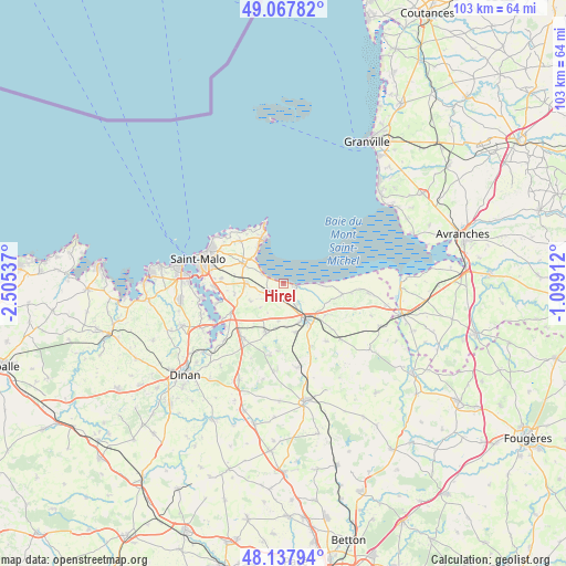
Hirel GPS coordinates[2]
48° 36' 18.072" North, 1° 48' 8.064" West
| Map corner | latitude | longitude |
|---|---|---|
| Upper-left | 49.06782°, | -2.50537° |
| Center: | 48.60502°, | -1.80224° |
| Lower-right: | 48.13794°, | -1.09912° |
| Map W x H: | 103.4×103.4 km | = 64.2×64.2mi |
| max Lat: | 51.07786° ⇑29% North |
| Hirel: | 48.60502° |
| min Lat: | ⇓71% South 41.3874° |
| min Long | Hirel | max Long |
| -5.08615° | -1.80224° | 9.52242° |
| W 6%⇐ | ⇒94% E |
Elevation
Elevation of Hirel is 7 m = 23 ft, and this is 186.7 m = 613 ft below average elevation for this country.
| Max E: |
2333 m = 7654 ft | 98.6% |
| Avg. | 193.7 m = 635 ft | |
| Hirel | 7 m = 23 ft | |
Min E: |
-1 m = -3 ft | 1.4% |
See also: France elevation on elevation.city.
Geographical zone
Hirel is located in North temperate zone (between Tropic of Cancer and the Arctic Circle). Distance of this North polar circle is 1996.8 km =1240.8 mi to North.| Distance of | km | miles | from Hirel |
|---|---|---|---|
| North Pole | 4602.7 | 2860 | to North |
| Arctic Circle | 1996.8 | 1240.8 | to North |
| Tropic Cancer | 2798.5 | 1738.9 | to South |
| Equator | 5404.4 | 3358.1 | to South |


Nearby cities:
15 places around Hirel: (largest is in red/bold)
• Baguer-Morvan
9.1 km =5.7 mi,  166°
166°
• Baguer-Pican
9.6 km =6 mi,  127°
127°
• Cancale
8.7 km =5.4 mi,  335°
335°
• Cherrueix
7.2 km =4.5 mi,  88°
88°
• Châteauneuf-d’Ille-et-Vilaine
10.5 km =6.5 mi,  242°
242°
• Dol-de-Bretagne
7.4 km =4.6 mi,  149°
149°
• La Fresnais
3.1 km =1.9 mi,  248°
248°
• La Gouesnière
6.7 km =4.2 mi,  269°
269°
• Le Vivier-sur-Mer
2.2 km =1.4 mi,  99°
99°
• Plerguer
9.3 km =5.8 mi,  201°
201°
• Roz-Landrieux
6.9 km =4.3 mi,  188°
188°
• Saint-Benoît-des-Ondes
3.8 km =2.4 mi,  291°
291°
• Saint-Guinoux
6.8 km =4.2 mi, 241°
• Saint-Méloir-des-Ondes
8.4 km =5.2 mi,  295°
295°
• Saint-Père
9.2 km =5.7 mi,  257°
257°
Sources, notices
• [Note1] Compared only with cities in France existing in our database
• [Src1] Map data: © OpenStreetMap contributors (CC-BY-SA)
• [Src2] Other city data from geonames.org with taken over terms of usage.
• [Src3] Geographical zone / Annual Mean Temperature by Robert A. Rohde @ Wikipedia
