Ourville-en-Caux geodata
Ourville-en-Caux (Normandy) is a populated place; located in France in Europe/Paris (GMT+2) time zone. With population of 1,060 people, there are 8398 cities with bigger population in this country. Compared to other cities in France, 91.8% of cities are located further ↓South; 72.3% of cities are located further →East and 54.4% of cities have higher elevation than Ourville-en-Caux. Note1
Administrative division(s):
- Level 1: Normandy
- Level 2: Seine-Maritime
- Level 3: Arrondissement de Dieppe
- Level 4: Ourville-en-Caux


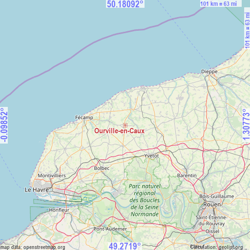
Ourville-en-Caux GPS coordinates[2]
49° 43' 42.744" North, 0° 36' 16.56" East
| Map corner | latitude | longitude |
|---|---|---|
| Upper-left | 50.18092°, | -0.09852° |
| Center: | 49.72854°, | 0.6046° |
| Lower-right: | 49.2719°, | 1.30773° |
| Map W x H: | 101.1×101.1 km | = 62.8×62.8mi |
| max Lat: | 51.07786° ⇑8.2% North |
| Ourville-en-Caux: | 49.72854° |
| min Lat: | ⇓91.8% South 41.3874° |
| min Long | Ourville-en-Cau | max Long |
| -5.08615° | 0.6046° | 9.52242° |
| W 27.7%⇐ | ⇒72.3% E |
Elevation
Elevation of Ourville-en-Caux is 118 m = 387 ft, and this is 75.7 m = 248 ft below average elevation for this country.
| Max E: |
2333 m = 7654 ft | 54.4% |
| Avg. | 193.7 m = 635 ft | |
| Ourville-en-Caux | 118 m = 387 ft | |
Min E: |
-1 m = -3 ft | 45.6% |
See also: France elevation on elevation.city.
Geographical zone
Ourville-en-Caux is located in North temperate zone (between Tropic of Cancer and the Arctic Circle). Distance of this North polar circle is 1871.9 km =1163.1 mi to North.| Distance of | km | miles | from Ourville-en-Caux |
|---|---|---|---|
| North Pole | 4477.8 | 2782.4 | to North |
| Arctic Circle | 1871.9 | 1163.1 | to North |
| Tropic Cancer | 2923.4 | 1816.5 | to South |
| Equator | 5529.3 | 3435.7 | to South |


Nearby cities:
15 places around Ourville-en-Caux: (largest is in red/bold)
• Angerville-la-Martel
8.2 km =5.1 mi,  296°
296°
• Bertheauville
2.9 km =1.8 mi,  356°
356°
• Bosville
6.7 km =4.2 mi,  63°
63°
• Cany-Barville
7.1 km =4.4 mi,  19°
19°
• Colleville
10.7 km =6.6 mi,  282°
282°
• Fauville-en-Caux
8.5 km =5.3 mi,  186°
186°
• Grainville-la-Teinturière
3.3 km =2.1 mi,  50°
50°
• Hattenville
9.8 km =6.1 mi,  209°
209°
• Hautot-Saint-Sulpice
11.2 km =7 mi,  117°
117°
• Héricourt-en-Caux
7.6 km =4.7 mi, 119°
• Normanville
3.8 km =2.4 mi, 191°
• Saint-Martin-aux-Buneaux
11.2 km =7 mi,  341°
341°
• Sassetot-le-Mauconduit
10.2 km =6.3 mi,  326°
326°
• Valmont
6.8 km =4.2 mi, 284°
• Vittefleur
10.6 km =6.6 mi,  12°
12°
Sources, notices
• [Note1] Compared only with cities in France existing in our database
• [Src1] Map data: © OpenStreetMap contributors (CC-BY-SA)
• [Src2] Other city data from geonames.org with taken over terms of usage.
• [Src3] Geographical zone / Annual Mean Temperature by Robert A. Rohde @ Wikipedia
