Heiligenberg geodata
Heiligenberg (Grand Est) is a populated place; located in France in Europe/Paris (GMT+2) time zone. With population of 607 people, there are 13209 cities with bigger population in this country. Compared to other cities in France, 69.2% of cities are located further ↓South; 97.2% of cities are located further ←West and 79.8% of cities have lower elevation than Heiligenberg. Note1
Administrative division(s):
- Level 1: Grand Est
- Level 2: Bas-Rhin
- Level 3: Arrondissement de Molsheim
- Level 4: Heiligenberg


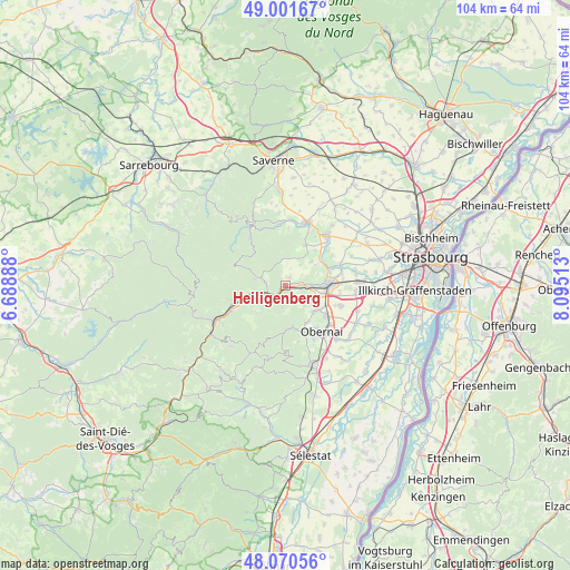
Heiligenberg GPS coordinates[2]
48° 32' 17.736" North, 7° 23' 31.2" East
| Map corner | latitude | longitude |
|---|---|---|
| Upper-left | 49.00167°, | 6.68888° |
| Center: | 48.53826°, | 7.392° |
| Lower-right: | 48.07056°, | 8.09513° |
| Map W x H: | 103.5×103.5 km | = 64.3×64.3mi |
| max Lat: | 51.07786° ⇑30.8% North |
| Heiligenberg: | 48.53826° |
| min Lat: | ⇓69.2% South 41.3874° |
| min Long | Heiligenberg | max Long |
| -5.08615° | 7.392° | 9.52242° |
| W 97.2%⇐ | ⇒2.8% E |
Elevation
Elevation of Heiligenberg is 288 m = 945 ft, and this is 94.3 m = 309 ft above average elevation for this country.
| Max E: |
2333 m = 7654 ft | 20.2% |
| Heiligenberg | 288 m 945 ft | |
| Avg. | 193.7 m = 635 ft | |
Min E: |
-1 m = -3 ft | 79.8% |
See also: France elevation on elevation.city.
Geographical zone
Heiligenberg is located in North temperate zone (between Tropic of Cancer and the Arctic Circle). Distance of this North polar circle is 2004.2 km =1245.4 mi to North.| Distance of | km | miles | from Heiligenberg |
|---|---|---|---|
| North Pole | 4610.1 | 2864.6 | to North |
| Arctic Circle | 2004.2 | 1245.4 | to North |
| Tropic Cancer | 2791 | 1734.2 | to South |
| Equator | 5396.9 | 3353.5 | to South |


Nearby cities:
15 places around Heiligenberg: (largest is in red/bold)
• Bergbieten
6.4 km =4 mi,  48°
48°
• Dangolsheim
6.5 km =4 mi,  55°
55°
• Dinsheim-sur-Bruche
2.6 km =1.6 mi,  79°
79°
• Dorlisheim
7.1 km =4.4 mi,  102°
102°
• Grendelbruch
7.2 km =4.5 mi,  225°
225°
• Gresswiller
3 km =1.9 mi, 96°
• Mollkirch
3.6 km =2.2 mi,  187°
187°
• Molsheim
7.4 km =4.6 mi,  88°
88°
• Mutzig
4.7 km =2.9 mi, 87°
• Niederhaslach
3.7 km =2.3 mi,  277°
277°
• Oberhaslach
4.6 km =2.9 mi,  287°
287°
• Rosenwiller
5 km =3.1 mi,  136°
136°
• Rosheim
7.4 km =4.6 mi,  128°
128°
• Still
1.6 km =1 mi,  35°
35°
• Urmatt
5 km =3.1 mi,  256°
256°
Sources, notices
• [Note1] Compared only with cities in France existing in our database
• [Src1] Map data: © OpenStreetMap contributors (CC-BY-SA)
• [Src2] Other city data from geonames.org with taken over terms of usage.
• [Src3] Geographical zone / Annual Mean Temperature by Robert A. Rohde @ Wikipedia
