Hautot-sur-Mer geodata
Hautot-sur-Mer (Normandy) is a populated place; located in France in Europe/Paris (GMT+2) time zone. With population of 2,193 people, there are 4381 cities with bigger population in this country. Compared to other cities in France, 93% of cities are located further ↓South; 68.5% of cities are located further →East and 60.8% of cities have higher elevation than Hautot-sur-Mer. Note1
Administrative division(s):
- Level 1: Normandy
- Level 2: Seine-Maritime
- Level 3: Arrondissement de Dieppe
- Level 4: Hautot-sur-Mer


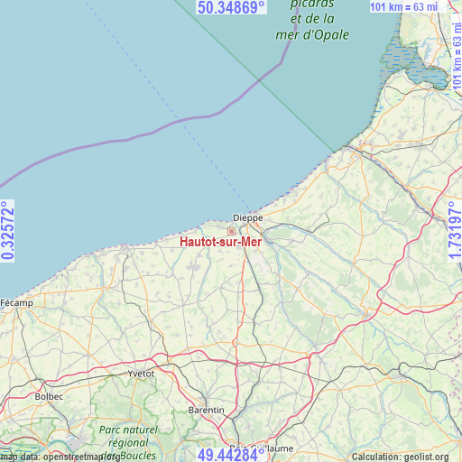
Hautot-sur-Mer GPS coordinates[2]
49° 53' 52.404" North, 1° 1' 43.824" East
| Map corner | latitude | longitude |
|---|---|---|
| Upper-left | 50.34869°, | 0.32572° |
| Center: | 49.89789°, | 1.02884° |
| Lower-right: | 49.44284°, | 1.73197° |
| Map W x H: | 100.7×100.7 km | = 62.6×62.6mi |
| max Lat: | 51.07786° ⇑7% North |
| Hautot-sur-Mer: | 49.89789° |
| min Lat: | ⇓93% South 41.3874° |
| min Long | Hautot-sur-Mer | max Long |
| -5.08615° | 1.02884° | 9.52242° |
| W 31.5%⇐ | ⇒68.5% E |
Elevation
Elevation of Hautot-sur-Mer is 100 m = 328 ft, and this is 93.7 m = 307 ft below average elevation for this country.
| Max E: |
2333 m = 7654 ft | 60.8% |
| Avg. | 193.7 m = 635 ft | |
| Hautot-sur-Mer | 100 m = 328 ft | |
Min E: |
-1 m = -3 ft | 39.2% |
See also: France elevation on elevation.city.
Geographical zone
Hautot-sur-Mer is located in North temperate zone (between Tropic of Cancer and the Arctic Circle). Distance of this North polar circle is 1853 km =1151.4 mi to North.| Distance of | km | miles | from Hautot-sur-Mer |
|---|---|---|---|
| North Pole | 4458.9 | 2770.6 | to North |
| Arctic Circle | 1853 | 1151.4 | to North |
| Tropic Cancer | 2942.2 | 1828.2 | to South |
| Equator | 5548.1 | 3447.4 | to South |


Nearby cities:
15 places around Hautot-sur-Mer: (largest is in red/bold)
• Arques-la-Bataille
7.4 km =4.6 mi,  104°
104°
• Auppegard
7.6 km =4.7 mi,  180°
180°
• Avremesnil
8.9 km =5.5 mi,  233°
233°
• Dieppe
4.4 km =2.7 mi,  53°
53°
• Grèges
8.9 km =5.5 mi,  72°
72°
• Gueures
7.6 km =4.7 mi,  218°
218°
• Longueil
4.7 km =2.9 mi,  250°
250°
• Martin-Église
8.1 km =5 mi,  86°
86°
• Offranville
3.2 km =2 mi,  154°
154°
• Ouville-la-Rivière
5.6 km =3.5 mi,  241°
241°
• Rouxmesnil-Bouteilles
3.8 km =2.4 mi,  75°
75°
• Saint-Aubin-sur-Scie
4.1 km =2.5 mi,  135°
135°
• Sainte-Marguerite-sur-Mer
6 km =3.7 mi,  282°
282°
• Tourville-sur-Arques
6.8 km =4.2 mi,  129°
129°
• Varengeville-sur-Mer
2.6 km =1.6 mi,  287°
287°
Sources, notices
• [Note1] Compared only with cities in France existing in our database
• [Src1] Map data: © OpenStreetMap contributors (CC-BY-SA)
• [Src2] Other city data from geonames.org with taken over terms of usage.
• [Src3] Geographical zone / Annual Mean Temperature by Robert A. Rohde @ Wikipedia
