Gueures geodata
Gueures (Normandy) is a populated place; located in France in Europe/Paris (GMT+2) time zone. With population of 542 people, there are 14349 cities with bigger population in this country. Compared to other cities in France, 92.6% of cities are located further ↓South; 69.1% of cities are located further →East and 93.1% of cities have higher elevation than Gueures. Note1
Administrative division(s):
- Level 1: Normandy
- Level 2: Seine-Maritime
- Level 3: Arrondissement de Dieppe
- Level 4: Gueures


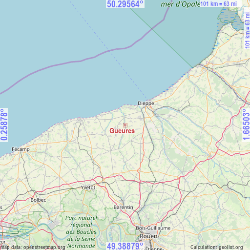
Gueures GPS coordinates[2]
49° 50' 39.624" North, 0° 57' 42.84" East
| Map corner | latitude | longitude |
|---|---|---|
| Upper-left | 50.29564°, | 0.25878° |
| Center: | 49.84434°, | 0.9619° |
| Lower-right: | 49.38879°, | 1.66503° |
| Map W x H: | 100.8×100.8 km | = 62.6×62.6mi |
| max Lat: | 51.07786° ⇑7.4% North |
| Gueures: | 49.84434° |
| min Lat: | ⇓92.6% South 41.3874° |
| min Long | Gueures | max Long |
| -5.08615° | 0.9619° | 9.52242° |
| W 30.9%⇐ | ⇒69.1% E |
Elevation
Elevation of Gueures is 22 m = 72 ft, and this is 171.7 m = 563 ft below average elevation for this country.
| Max E: |
2333 m = 7654 ft | 93.1% |
| Avg. | 193.7 m = 635 ft | |
| Gueures | 22 m = 72 ft | |
Min E: |
-1 m = -3 ft | 6.9% |
See also: France elevation on elevation.city.
Geographical zone
Gueures is located in North temperate zone (between Tropic of Cancer and the Arctic Circle). Distance of this North polar circle is 1859 km =1155.1 mi to North.| Distance of | km | miles | from Gueures |
|---|---|---|---|
| North Pole | 4464.9 | 2774.4 | to North |
| Arctic Circle | 1859 | 1155.1 | to North |
| Tropic Cancer | 2936.3 | 1824.5 | to South |
| Equator | 5542.2 | 3443.8 | to South |


Nearby cities:
15 places around Gueures: (largest is in red/bold)
• Auppegard
5 km =3.1 mi,  109°
109°
• Avremesnil
2.5 km =1.6 mi,  285°
285°
• Bacqueville-en-Caux
6.9 km =4.3 mi,  156°
156°
• Brachy
3.2 km =2 mi,  195°
195°
• Fontaine-le-Dun
8.7 km =5.4 mi,  245°
245°
• Gruchet-Saint-Siméon
5.6 km =3.5 mi,  239°
239°
• Hautot-sur-Mer
7.6 km =4.7 mi,  38°
38°
• Longueil
4.3 km =2.7 mi,  4°
4°
• Luneray
3.8 km =2.4 mi, 241°
• Offranville
6.9 km =4.3 mi,  63°
63°
• Ouville-la-Rivière
3.3 km =2.1 mi,  357°
357°
• Saint-Aubin-sur-Scie
8.2 km =5.1 mi,  68°
68°
• Sainte-Marguerite-sur-Mer
7.3 km =4.5 mi,  351°
351°
• Tourville-sur-Arques
10.2 km =6.3 mi,  80°
80°
• Varengeville-sur-Mer
7.1 km =4.4 mi,  19°
19°
Sources, notices
• [Note1] Compared only with cities in France existing in our database
• [Src1] Map data: © OpenStreetMap contributors (CC-BY-SA)
• [Src2] Other city data from geonames.org with taken over terms of usage.
• [Src3] Geographical zone / Annual Mean Temperature by Robert A. Rohde @ Wikipedia
