Ouville-la-Rivière geodata
Ouville-la-Rivière (Normandy) is a populated place; located in France in Europe/Paris (GMT+2) time zone. With population of 589 people, there are 13496 cities with bigger population in this country. Compared to other cities in France, 92.8% of cities are located further ↓South; 69.1% of cities are located further →East and 96.7% of cities have higher elevation than Ouville-la-Rivière. Note1
Administrative division(s):
- Level 1: Normandy
- Level 2: Seine-Maritime
- Level 3: Arrondissement de Dieppe
- Level 4: Ouville-la-Rivière


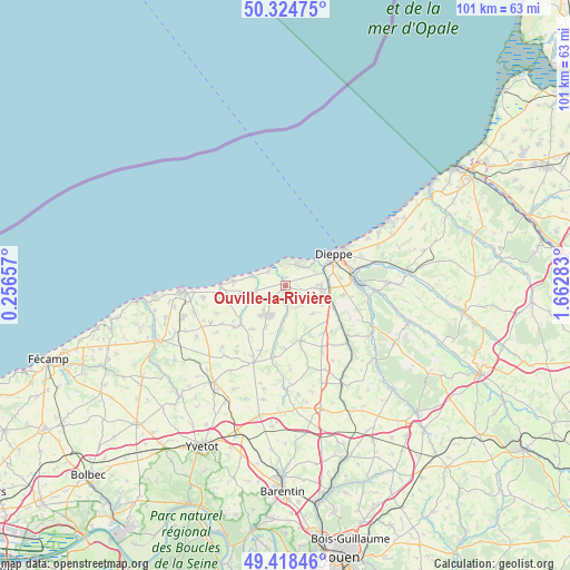
Ouville-la-Rivière GPS coordinates[2]
49° 52' 25.428" North, 0° 57' 34.92" East
| Map corner | latitude | longitude |
|---|---|---|
| Upper-left | 50.32475°, | 0.25657° |
| Center: | 49.87373°, | 0.9597° |
| Lower-right: | 49.41846°, | 1.66283° |
| Map W x H: | 100.8×100.8 km | = 62.6×62.6mi |
| max Lat: | 51.07786° ⇑7.2% North |
| Ouville-la-Rivière: | 49.87373° |
| min Lat: | ⇓92.8% South 41.3874° |
| min Long | Ouville-la-Rivi | max Long |
| -5.08615° | 0.9597° | 9.52242° |
| W 30.9%⇐ | ⇒69.1% E |
Elevation
Elevation of Ouville-la-Rivière is 12 m = 39 ft, and this is 181.7 m = 596 ft below average elevation for this country.
| Max E: |
2333 m = 7654 ft | 96.7% |
| Avg. | 193.7 m = 635 ft | |
| Ouville-la-Rivière | 12 m = 39 ft | |
Min E: |
-1 m = -3 ft | 3.3% |
See also: France elevation on elevation.city.
Geographical zone
Ouville-la-Rivière is located in North temperate zone (between Tropic of Cancer and the Arctic Circle). Distance of this North polar circle is 1855.7 km =1153.1 mi to North.| Distance of | km | miles | from Ouville-la-Rivière |
|---|---|---|---|
| North Pole | 4461.6 | 2772.3 | to North |
| Arctic Circle | 1855.7 | 1153.1 | to North |
| Tropic Cancer | 2939.5 | 1826.5 | to South |
| Equator | 5545.4 | 3445.8 | to South |


Nearby cities:
15 places around Ouville-la-Rivière: (largest is in red/bold)
• Auppegard
6.9 km =4.3 mi,  135°
135°
• Avremesnil
3.4 km =2.1 mi,  220°
220°
• Bacqueville-en-Caux
10 km =6.2 mi,  163°
163°
• Brachy
6.4 km =4 mi,  186°
186°
• Dieppe
10 km =6.2 mi,  57°
57°
• Gruchet-Saint-Siméon
7.7 km =4.8 mi, 217°
• Gueures
3.3 km =2.1 mi,  177°
177°
• Hautot-sur-Mer
5.6 km =3.5 mi, 61°
• Longueil
1.2 km =0.7 mi,  25°
25°
• Luneray
6 km =3.7 mi,  211°
211°
• Offranville
6.3 km =3.9 mi,  91°
91°
• Rouxmesnil-Bouteilles
9.3 km =5.8 mi,  67°
67°
• Saint-Aubin-sur-Scie
7.8 km =4.8 mi, 91°
• Sainte-Marguerite-sur-Mer
4.1 km =2.5 mi,  346°
346°
• Varengeville-sur-Mer
4.3 km =2.7 mi,  36°
36°
Sources, notices
• [Note1] Compared only with cities in France existing in our database
• [Src1] Map data: © OpenStreetMap contributors (CC-BY-SA)
• [Src2] Other city data from geonames.org with taken over terms of usage.
• [Src3] Geographical zone / Annual Mean Temperature by Robert A. Rohde @ Wikipedia
