Hautefage-la-Tour geodata
Hautefage-la-Tour (Nouvelle-Aquitaine) is a populated place; located in France in Europe/Paris (GMT+2) time zone. With population of 695 people, there are 11873 cities with bigger population in this country. Compared to other cities in France, 84.7% of cities are located further ↑North; 70.6% of cities are located further →East and 68.5% of cities have lower elevation than Hautefage-la-Tour. Note1
Administrative division(s):
- Level 1: Nouvelle-Aquitaine
- Level 2: Département du Lot-et-Garonne
- Level 3: Arrondissement de Villeneuve-sur-Lot
- Level 4: Hautefage-la-Tour


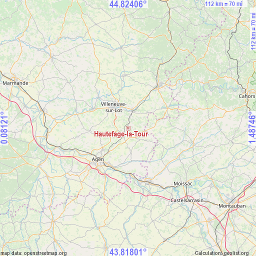
Hautefage-la-Tour GPS coordinates[2]
44° 19' 23.484" North, 0° 47' 3.588" East
| Map corner | latitude | longitude |
|---|---|---|
| Upper-left | 44.82406°, | 0.08121° |
| Center: | 44.32319°, | 0.78433° |
| Lower-right: | 43.81801°, | 1.48746° |
| Map W x H: | 111.9×111.9 km | = 69.5×69.5mi |
| max Lat: | 51.07786° ⇑84.7% North |
| Hautefage-la-Tour: | 44.32319° |
| min Lat: | ⇓15.3% South 41.3874° |
| min Long | Hautefage-la-To | max Long |
| -5.08615° | 0.78433° | 9.52242° |
| W 29.4%⇐ | ⇒70.6% E |
Elevation
Elevation of Hautefage-la-Tour is 211 m = 692 ft, and this is 17.3 m = 57 ft above average elevation for this country.
| Max E: |
2333 m = 7654 ft | 31.5% |
| Hautefage-la-Tour | 211 m 692 ft | |
| Avg. | 193.7 m = 635 ft | |
Min E: |
-1 m = -3 ft | 68.5% |
See also: France elevation on elevation.city.
Geographical zone
Hautefage-la-Tour is located in North temperate zone (between Tropic of Cancer and the Arctic Circle). Distance of this Northern Tropic circle is 2322.4 km =1443.1 mi to South.| Distance of | km | miles | from Hautefage-la-Tour |
|---|---|---|---|
| North Pole | 5078.8 | 3155.8 | to North |
| Arctic Circle | 2472.9 | 1536.6 | to North |
| Tropic Cancer | 2322.4 | 1443.1 | to South |
| Equator | 4928.3 | 3062.3 | to South |


Nearby cities:
15 places around Hautefage-la-Tour: (largest is in red/bold)
• Allez-et-Cazeneuve
15.8 km =9.8 mi,  302°
302°
• Beauville
9.3 km =5.8 mi,  123°
123°
• Bias
13.8 km =8.6 mi,  318°
318°
• Foulayronnes
14.4 km =8.9 mi,  230°
230°
• La Croix-Blanche
7.9 km =4.9 mi,  246°
246°
• Laroque-Timbaut
4.9 km =3 mi,  200°
200°
• Laugnac
14.3 km =8.9 mi,  262°
262°
• Pont-du-Casse
13.4 km =8.3 mi,  218°
218°
• Pujols
11 km =6.8 mi, 315°
• Puymirol
15.2 km =9.4 mi,  176°
176°
• Saint-Antoine-de-Ficalba
5.4 km =3.4 mi,  280°
280°
• Saint-Pierre-de-Clairac
16.1 km =10 mi,  186°
186°
• Saint-Sylvestre-sur-Lot
8.3 km =5.2 mi,  11°
11°
• Trentels
13.9 km =8.6 mi,  26°
26°
• Villeneuve-sur-Lot
11.4 km =7.1 mi,  326°
326°
Sources, notices
• [Note1] Compared only with cities in France existing in our database
• [Src1] Map data: © OpenStreetMap contributors (CC-BY-SA)
• [Src2] Other city data from geonames.org with taken over terms of usage.
• [Src3] Geographical zone / Annual Mean Temperature by Robert A. Rohde @ Wikipedia
