Sainte-Croix-en-Plaine geodata
Sainte-Croix-en-Plaine (Grand Est) is a populated place; located in France in Europe/Paris (GMT+2) time zone. With population of 2,416 people, there are 4004 cities with bigger population in this country. Compared to other cities in France, 59.4% of cities are located further ↓South; 97.2% of cities are located further ←West and 65.6% of cities have lower elevation than Sainte-Croix-en-Plaine. Note1
Administrative division(s):
- Level 1: Grand Est
- Level 2: Haut-Rhin
- Level 3: Arrondissement de Colmar-Ribeauvillé
- Level 4: Sainte-Croix-en-Plaine
Current local time in Sainte-Croix-en-Plaine:
07:57 AM, SaturdayDifference from your time zone: hours


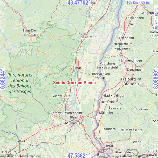
Sainte-Croix-en-Plaine GPS coordinates[2]
48° 0' 31.536" North, 7° 23' 8.016" East
| Map corner | latitude | longitude |
|---|---|---|
| Upper-left | 48.47702°, | 6.68244° |
| Center: | 48.00876°, | 7.38556° |
| Lower-right: | 47.53621°, | 8.08869° |
| Map W x H: | 104.6×104.6 km | = 65×65mi |
| max Lat: | 51.07786° ⇑40.6% North |
| Sainte-Croix-en-Plaine: | 48.00876° |
| min Lat: | ⇓59.4% South 41.3874° |
| min Long | Sainte-Croix-en | max Long |
| -5.08615° | 7.38556° | 9.52242° |
| W 97.2%⇐ | ⇒2.8% E |
Elevation
Elevation of Sainte-Croix-en-Plaine is 197 m = 646 ft, and this is 3.3 m = 11 ft above average elevation for this country.
| Max E: |
2333 m = 7654 ft | 34.4% |
| Sainte-Croix-en-Plaine | 197 m 646 ft | |
| Avg. | 193.7 m = 635 ft | |
Min E: |
-1 m = -3 ft | 65.6% |
See also: France elevation on elevation.city.
Geographical zone
Sainte-Croix-en-Plaine is located in North temperate zone (between Tropic of Cancer and the Arctic Circle). Distance of this North polar circle is 2063.1 km =1282 mi to North.| Distance of | km | miles | from Sainte-Croix-en-Plaine |
|---|---|---|---|
| North Pole | 4669 | 2901.2 | to North |
| Arctic Circle | 2063.1 | 1282 | to North |
| Tropic Cancer | 2732.2 | 1697.7 | to South |
| Equator | 5338.1 | 3316.9 | to South |


Nearby cities:
15 places around Sainte-Croix-en-Plaine: (largest is in red/bold)
• Andolsheim
6.3 km =3.9 mi,  21°
21°
• Colmar
8.3 km =5.2 mi,  344°
344°
• Dessenheim
8.4 km =5.2 mi,  114°
114°
• Eguisheim
7 km =4.3 mi,  302°
302°
• Gueberschwihr
8.2 km =5.1 mi,  266°
266°
• Hattstatt
6.3 km =3.9 mi, 272°
• Herrlisheim-près-Colmar
4.5 km =2.8 mi,  283°
283°
• Horbourg-Wihr
8.1 km =5 mi,  4°
4°
• Logelheim
2.1 km =1.3 mi,  51°
51°
• Niederhergheim
2.7 km =1.7 mi,  160°
160°
• Oberentzen
7.3 km =4.5 mi,  185°
185°
• Oberhergheim
4.7 km =2.9 mi,  171°
171°
• Pfaffenheim
7.6 km =4.7 mi,  250°
250°
• Sundhoffen
4.3 km =2.7 mi,  28°
28°
• Vœgtlinshoffen
7.8 km =4.8 mi, 279°
Sources, notices
• [Note1] Compared only with cities in France existing in our database
• [Src1] Map data: © OpenStreetMap contributors (CC-BY-SA)
• [Src2] Other city data from geonames.org with taken over terms of usage.
• [Src3] Geographical zone / Annual Mean Temperature by Robert A. Rohde @ Wikipedia
