Hantay geodata
Hantay (Hauts-de-France) is a populated place; located in France in Europe/Paris (GMT+2) time zone. With population of 904 people, there are 9617 cities with bigger population in this country. Compared to other cities in France, 97.6% of cities are located further ↓South; 55.9% of cities are located further ←West and 93.1% of cities have higher elevation than Hantay. Note1
Administrative division(s):
- Level 1: Hauts-de-France
- Level 2: Nord
- Level 3: Arrondissement de Lille
- Level 4: Hantay


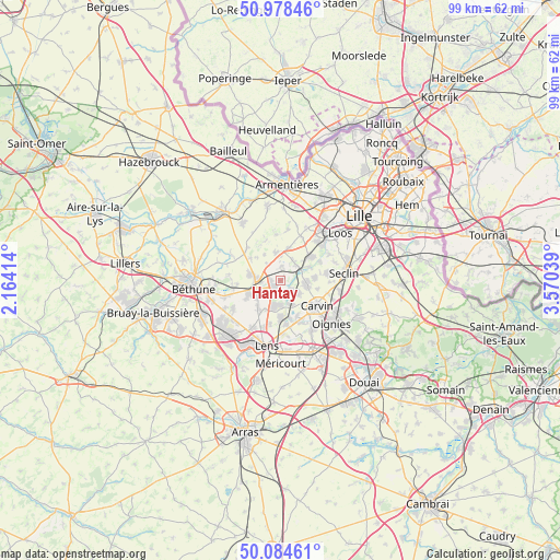
Hantay GPS coordinates[2]
50° 32' 1.14" North, 2° 52' 2.136" East
| Map corner | latitude | longitude |
|---|---|---|
| Upper-left | 50.97846°, | 2.16414° |
| Center: | 50.53365°, | 2.86726° |
| Lower-right: | 50.08461°, | 3.57039° |
| Map W x H: | 99.4×99.4 km | = 61.8×61.8mi |
| max Lat: | 51.07786° ⇑2.4% North |
| Hantay: | 50.53365° |
| min Lat: | ⇓97.6% South 41.3874° |
| min Long | Hantay | max Long |
| -5.08615° | 2.86726° | 9.52242° |
| W 55.9%⇐ | ⇒44.1% E |
Elevation
Elevation of Hantay is 22 m = 72 ft, and this is 171.7 m = 563 ft below average elevation for this country.
| Max E: |
2333 m = 7654 ft | 93.1% |
| Avg. | 193.7 m = 635 ft | |
| Hantay | 22 m = 72 ft | |
Min E: |
-1 m = -3 ft | 6.9% |
See also: France elevation on elevation.city.
Geographical zone
Hantay is located in North temperate zone (between Tropic of Cancer and the Arctic Circle). Distance of this North polar circle is 1782.4 km =1107.5 mi to North.| Distance of | km | miles | from Hantay |
|---|---|---|---|
| North Pole | 4388.2 | 2726.7 | to North |
| Arctic Circle | 1782.4 | 1107.5 | to North |
| Tropic Cancer | 3012.9 | 1872.1 | to South |
| Equator | 5618.8 | 3491.4 | to South |


Nearby cities:
15 places around Hantay: (largest is in red/bold)
• Annoeullin
4.6 km =2.9 mi,  96°
96°
• Bauvin
2.6 km =1.6 mi,  134°
134°
• Billy-Berclau
1.8 km =1.1 mi,  182°
182°
• Don
4 km =2.5 mi,  64°
64°
• Douvrin
3.8 km =2.4 mi,  223°
223°
• Herlies
5 km =3.1 mi,  348°
348°
• Illies
4.1 km =2.5 mi,  319°
319°
• La Bassée
4.3 km =2.7 mi,  270°
270°
• Marquillies
2.5 km =1.6 mi,  5°
5°
• Meurchin
4.3 km =2.7 mi,  154°
154°
• Provin
3.6 km =2.2 mi, 126°
• Sainghin-en-Weppes
4 km =2.5 mi,  32°
32°
• Salomé
1.4 km =0.9 mi, 269°
• Violaines
5.6 km =3.5 mi,  279°
279°
• Wingles
4.5 km =2.8 mi,  191°
191°
Sources, notices
• [Note1] Compared only with cities in France existing in our database
• [Src1] Map data: © OpenStreetMap contributors (CC-BY-SA)
• [Src2] Other city data from geonames.org with taken over terms of usage.
• [Src3] Geographical zone / Annual Mean Temperature by Robert A. Rohde @ Wikipedia
