Billy-Berclau geodata
Billy-Berclau (Hauts-de-France) is a populated place; located in France in Europe/Paris (GMT+2) time zone. With population of 4,338 people, there are 2272 cities with bigger population in this country. Compared to other cities in France, 97.5% of cities are located further ↓South; 55.9% of cities are located further ←West and 91.6% of cities have higher elevation than Billy-Berclau. Note1
Administrative division(s):
- Level 1: Hauts-de-France
- Level 2: Pas-de-Calais
- Level 3: Arrondissement de Béthune
- Level 4: Billy-Berclau


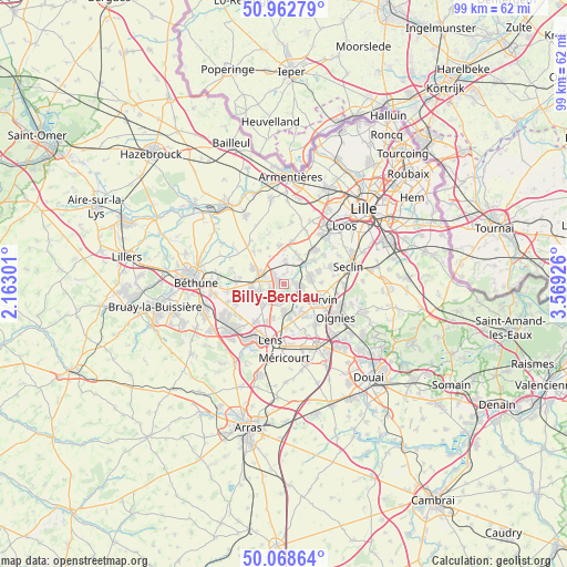
Billy-Berclau GPS coordinates[2]
50° 31' 4.188" North, 2° 51' 58.068" East
| Map corner | latitude | longitude |
|---|---|---|
| Upper-left | 50.96279°, | 2.16301° |
| Center: | 50.51783°, | 2.86613° |
| Lower-right: | 50.06864°, | 3.56926° |
| Map W x H: | 99.4×99.4 km | = 61.8×61.8mi |
| max Lat: | 51.07786° ⇑2.5% North |
| Billy-Berclau: | 50.51783° |
| min Lat: | ⇓97.5% South 41.3874° |
| min Long | Billy-Berclau | max Long |
| -5.08615° | 2.86613° | 9.52242° |
| W 55.9%⇐ | ⇒44.1% E |
Elevation
Elevation of Billy-Berclau is 26 m = 85 ft, and this is 167.7 m = 550 ft below average elevation for this country.
| Max E: |
2333 m = 7654 ft | 91.6% |
| Avg. | 193.7 m = 635 ft | |
| Billy-Berclau | 26 m = 85 ft | |
Min E: |
-1 m = -3 ft | 8.4% |
See also: France elevation on elevation.city.
Geographical zone
Billy-Berclau is located in North temperate zone (between Tropic of Cancer and the Arctic Circle). Distance of this North polar circle is 1784.1 km =1108.6 mi to North.| Distance of | km | miles | from Billy-Berclau |
|---|---|---|---|
| North Pole | 4390 | 2727.8 | to North |
| Arctic Circle | 1784.1 | 1108.6 | to North |
| Tropic Cancer | 3011.1 | 1871 | to South |
| Equator | 5617.1 | 3490.3 | to South |


Nearby cities:
15 places around Billy-Berclau: (largest is in red/bold)
• Annoeullin
4.8 km =3 mi,  74°
74°
• Bauvin
2 km =1.2 mi,  92°
92°
• Don
5.1 km =3.2 mi,  46°
46°
• Douvrin
2.7 km =1.7 mi,  249°
249°
• Haisnes
5.2 km =3.2 mi,  257°
257°
• Hantay
1.8 km =1.1 mi,  2°
2°
• Hulluch
4.9 km =3 mi,  230°
230°
• La Bassée
4.6 km =2.9 mi,  293°
293°
• Marquillies
4.2 km =2.6 mi, 4°
• Meurchin
2.9 km =1.8 mi,  138°
138°
• Pont-à-Vendin
5.2 km =3.2 mi,  161°
161°
• Provin
3 km =1.9 mi,  97°
97°
• Salomé
2.2 km =1.4 mi,  322°
322°
• Vendin-le-Vieil
4.9 km =3 mi,  179°
179°
• Wingles
2.8 km =1.7 mi,  196°
196°
Sources, notices
• [Note1] Compared only with cities in France existing in our database
• [Src1] Map data: © OpenStreetMap contributors (CC-BY-SA)
• [Src2] Other city data from geonames.org with taken over terms of usage.
• [Src3] Geographical zone / Annual Mean Temperature by Robert A. Rohde @ Wikipedia
