Illies geodata
Illies (Hauts-de-France) is a populated place; located in France in Europe/Paris (GMT+2) time zone. With population of 1,281 people, there are 7125 cities with bigger population in this country. Compared to other cities in France, 97.8% of cities are located further ↓South; 55.4% of cities are located further ←West and 91.2% of cities have higher elevation than Illies. Note1
Administrative division(s):
- Level 1: Hauts-de-France
- Level 2: Nord
- Level 3: Arrondissement de Lille
- Level 4: Illies


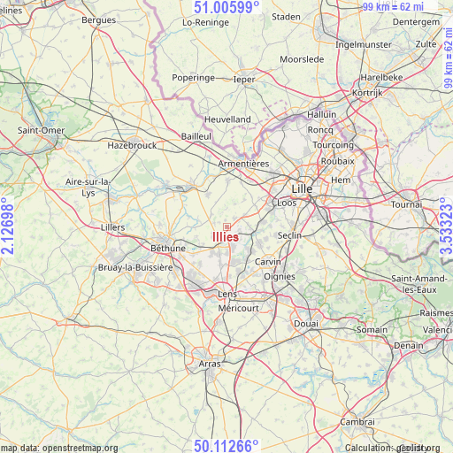
Illies GPS coordinates[2]
50° 33' 41.184" North, 2° 49' 48.396" East
| Map corner | latitude | longitude |
|---|---|---|
| Upper-left | 51.00599°, | 2.12698° |
| Center: | 50.56144°, | 2.83011° |
| Lower-right: | 50.11266°, | 3.53323° |
| Map W x H: | 99.3×99.3 km | = 61.7×61.7mi |
| max Lat: | 51.07786° ⇑2.2% North |
| Illies: | 50.56144° |
| min Lat: | ⇓97.8% South 41.3874° |
| min Long | Illies | max Long |
| -5.08615° | 2.83011° | 9.52242° |
| W 55.4%⇐ | ⇒44.6% E |
Elevation
Elevation of Illies is 27 m = 89 ft, and this is 166.7 m = 547 ft below average elevation for this country.
| Max E: |
2333 m = 7654 ft | 91.2% |
| Avg. | 193.7 m = 635 ft | |
| Illies | 27 m = 89 ft | |
Min E: |
-1 m = -3 ft | 8.8% |
See also: France elevation on elevation.city.
Geographical zone
Illies is located in North temperate zone (between Tropic of Cancer and the Arctic Circle). Distance of this North polar circle is 1779.3 km =1105.6 mi to North.| Distance of | km | miles | from Illies |
|---|---|---|---|
| North Pole | 4385.2 | 2724.8 | to North |
| Arctic Circle | 1779.3 | 1105.6 | to North |
| Tropic Cancer | 3016 | 1874.1 | to South |
| Equator | 5621.9 | 3493.3 | to South |


Nearby cities:
15 places around Illies: (largest is in red/bold)
• Aubers
3.8 km =2.4 mi,  356°
356°
• Billy-Berclau
5.5 km =3.4 mi,  152°
152°
• Douvrin
5.8 km =3.6 mi,  179°
179°
• Fournes-en-Weppes
4.8 km =3 mi,  57°
57°
• Fromelles
5.3 km =3.3 mi,  17°
17°
• Hantay
4.1 km =2.5 mi,  139°
139°
• Herlies
2.4 km =1.5 mi,  41°
41°
• La Bassée
3.5 km =2.2 mi,  209°
209°
• Lorgies
2.9 km =1.8 mi,  286°
286°
• Marquillies
2.9 km =1.8 mi,  102°
102°
• Neuve-Chapelle
4.3 km =2.7 mi,  308°
308°
• Richebourg-l'Avoué
5.8 km =3.6 mi,  279°
279°
• Sainghin-en-Weppes
4.8 km =3 mi,  86°
86°
• Salomé
3.3 km =2.1 mi,  158°
158°
• Violaines
3.7 km =2.3 mi,  233°
233°
Sources, notices
• [Note1] Compared only with cities in France existing in our database
• [Src1] Map data: © OpenStreetMap contributors (CC-BY-SA)
• [Src2] Other city data from geonames.org with taken over terms of usage.
• [Src3] Geographical zone / Annual Mean Temperature by Robert A. Rohde @ Wikipedia
