Provin geodata
Provin (Hauts-de-France) is a populated place; located in France in Europe/Paris (GMT+2) time zone. With population of 3,745 people, there are 2622 cities with bigger population in this country. Compared to other cities in France, 97.4% of cities are located further ↓South; 56.5% of cities are located further ←West and 92.4% of cities have higher elevation than Provin. Note1
Administrative division(s):
- Level 1: Hauts-de-France
- Level 2: Nord
- Level 3: Arrondissement de Lille
- Level 4: Provin


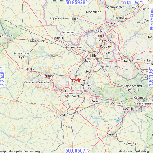
Provin GPS coordinates[2]
50° 30' 51.48" North, 2° 54' 28.584" East
| Map corner | latitude | longitude |
|---|---|---|
| Upper-left | 50.95929°, | 2.20481° |
| Center: | 50.5143°, | 2.90794° |
| Lower-right: | 50.06507°, | 3.61106° |
| Map W x H: | 99.4×99.4 km | = 61.8×61.8mi |
| max Lat: | 51.07786° ⇑2.6% North |
| Provin: | 50.5143° |
| min Lat: | ⇓97.4% South 41.3874° |
| min Long | Provin | max Long |
| -5.08615° | 2.90794° | 9.52242° |
| W 56.5%⇐ | ⇒43.5% E |
Elevation
Elevation of Provin is 24 m = 79 ft, and this is 169.7 m = 557 ft below average elevation for this country.
| Max E: |
2333 m = 7654 ft | 92.4% |
| Avg. | 193.7 m = 635 ft | |
| Provin | 24 m = 79 ft | |
Min E: |
-1 m = -3 ft | 7.6% |
See also: France elevation on elevation.city.
Geographical zone
Provin is located in North temperate zone (between Tropic of Cancer and the Arctic Circle). Distance of this North polar circle is 1784.5 km =1108.8 mi to North.| Distance of | km | miles | from Provin |
|---|---|---|---|
| North Pole | 4390.4 | 2728.1 | to North |
| Arctic Circle | 1784.5 | 1108.8 | to North |
| Tropic Cancer | 3010.7 | 1870.8 | to South |
| Equator | 5616.7 | 3490.1 | to South |


Nearby cities:
15 places around Provin: (largest is in red/bold)
• Allennes-les-Marais
4.1 km =2.5 mi,  51°
51°
• Annoeullin
2.4 km =1.5 mi, 45°
• Bauvin
1 km =0.6 mi,  287°
287°
• Billy-Berclau
3 km =1.9 mi,  277°
277°
• Carnin
3.8 km =2.4 mi,  81°
81°
• Carvin
4.3 km =2.7 mi,  124°
124°
• Don
3.9 km =2.4 mi,  10°
10°
• Estevelles
4.2 km =2.6 mi,  178°
178°
• Hantay
3.6 km =2.2 mi,  306°
306°
• Marquillies
5.3 km =3.3 mi,  330°
330°
• Meurchin
2.1 km =1.3 mi,  210°
210°
• Pont-à-Vendin
4.7 km =2.9 mi,  196°
196°
• Salomé
4.8 km =3 mi,  296°
296°
• Wingles
4.4 km =2.7 mi,  238°
238°
• Épinoy
4.3 km =2.7 mi,  142°
142°
Sources, notices
• [Note1] Compared only with cities in France existing in our database
• [Src1] Map data: © OpenStreetMap contributors (CC-BY-SA)
• [Src2] Other city data from geonames.org with taken over terms of usage.
• [Src3] Geographical zone / Annual Mean Temperature by Robert A. Rohde @ Wikipedia
