Guiscard geodata
Guiscard (Hauts-de-France) is a populated place; located in France in Europe/Paris (GMT+2) time zone. With population of 1,802 people, there are 5270 cities with bigger population in this country. Compared to other cities in France, 91.2% of cities are located further ↓South; 58.5% of cities are located further ←West and 77% of cities have higher elevation than Guiscard. Note1
Administrative division(s):
- Level 1: Hauts-de-France
- Level 2: Département de l'Oise
- Level 3: Arrondissement de Compiègne
- Level 4: Guiscard


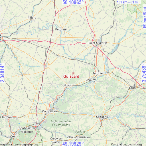
Guiscard GPS coordinates[2]
49° 39' 23.76" North, 3° 3' 4.572" East
| Map corner | latitude | longitude |
|---|---|---|
| Upper-left | 50.10965°, | 2.34814° |
| Center: | 49.6566°, | 3.05127° |
| Lower-right: | 49.19929°, | 3.75439° |
| Map W x H: | 101.2×101.2 km | = 62.9×62.9mi |
| max Lat: | 51.07786° ⇑8.8% North |
| Guiscard: | 49.6566° |
| min Lat: | ⇓91.2% South 41.3874° |
| min Long | Guiscard | max Long |
| -5.08615° | 3.05127° | 9.52242° |
| W 58.5%⇐ | ⇒41.5% E |
Elevation
Elevation of Guiscard is 62 m = 203 ft, and this is 131.7 m = 432 ft below average elevation for this country.
| Max E: |
2333 m = 7654 ft | 77% |
| Avg. | 193.7 m = 635 ft | |
| Guiscard | 62 m = 203 ft | |
Min E: |
-1 m = -3 ft | 23% |
See also: France elevation on elevation.city.
Geographical zone
Guiscard is located in North temperate zone (between Tropic of Cancer and the Arctic Circle). Distance of this North polar circle is 1879.9 km =1168.1 mi to North.| Distance of | km | miles | from Guiscard |
|---|---|---|---|
| North Pole | 4485.8 | 2787.3 | to North |
| Arctic Circle | 1879.9 | 1168.1 | to North |
| Tropic Cancer | 2915.4 | 1811.5 | to South |
| Equator | 5521.3 | 3430.8 | to South |


Nearby cities:
15 places around Guiscard: (largest is in red/bold)
• Appilly
9.4 km =5.8 mi,  149°
149°
• Beaulieu-les-Fontaines
10 km =6.2 mi,  272°
272°
• Brouchy
7.5 km =4.7 mi,  27°
27°
• Crisolles
4.6 km =2.9 mi,  214°
214°
• Cugny
9.2 km =5.7 mi,  52°
52°
• Eppeville
9.3 km =5.8 mi,  359°
359°
• Ercheu
9.4 km =5.8 mi,  302°
302°
• Esmery-Hallon
7.3 km =4.5 mi,  337°
337°
• Genvry
6.6 km =4.1 mi,  220°
220°
• Ham
10.2 km =6.3 mi,  8°
8°
• Morlincourt
9.7 km =6 mi,  186°
186°
• Muille-Villette
8 km =5 mi, 8°
• Muirancourt
3.2 km =2 mi,  245°
245°
• Noyon
8.9 km =5.5 mi,  204°
204°
• Salency
7.6 km =4.7 mi,  181°
181°
Sources, notices
• [Note1] Compared only with cities in France existing in our database
• [Src1] Map data: © OpenStreetMap contributors (CC-BY-SA)
• [Src2] Other city data from geonames.org with taken over terms of usage.
• [Src3] Geographical zone / Annual Mean Temperature by Robert A. Rohde @ Wikipedia
