Muille-Villette geodata
Muille-Villette (Hauts-de-France) is a populated place; located in France in Europe/Paris (GMT+2) time zone. With population of 807 people, there are 10522 cities with bigger population in this country. Compared to other cities in France, 91.8% of cities are located further ↓South; 58.8% of cities are located further ←West and 75% of cities have higher elevation than Muille-Villette. Note1
Administrative division(s):
- Level 1: Hauts-de-France
- Level 2: Somme
- Level 3: Arrondissement de Péronne
- Level 4: Muille-Villette


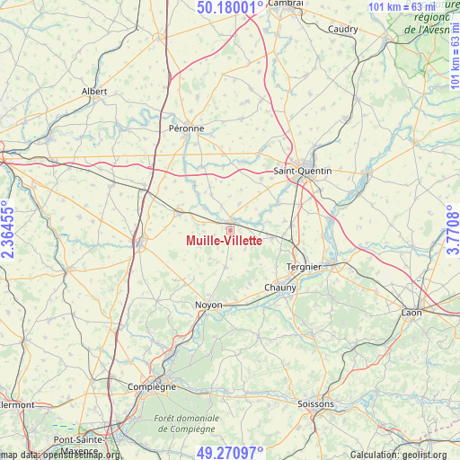
Muille-Villette GPS coordinates[2]
49° 43' 39.432" North, 3° 4' 3.648" East
| Map corner | latitude | longitude |
|---|---|---|
| Upper-left | 50.18001°, | 2.36455° |
| Center: | 49.72762°, | 3.06768° |
| Lower-right: | 49.27097°, | 3.7708° |
| Map W x H: | 101.1×101.1 km | = 62.8×62.8mi |
| max Lat: | 51.07786° ⇑8.2% North |
| Muille-Villette: | 49.72762° |
| min Lat: | ⇓91.8% South 41.3874° |
| min Long | Muille-Villette | max Long |
| -5.08615° | 3.06768° | 9.52242° |
| W 58.8%⇐ | ⇒41.2% E |
Elevation
Elevation of Muille-Villette is 67 m = 220 ft, and this is 126.7 m = 416 ft below average elevation for this country.
| Max E: |
2333 m = 7654 ft | 75% |
| Avg. | 193.7 m = 635 ft | |
| Muille-Villette | 67 m = 220 ft | |
Min E: |
-1 m = -3 ft | 25% |
See also: France elevation on elevation.city.
Geographical zone
Muille-Villette is located in North temperate zone (between Tropic of Cancer and the Arctic Circle). Distance of this North polar circle is 1872 km =1163.2 mi to North.| Distance of | km | miles | from Muille-Villette |
|---|---|---|---|
| North Pole | 4477.9 | 2782.4 | to North |
| Arctic Circle | 1872 | 1163.2 | to North |
| Tropic Cancer | 2923.3 | 1816.5 | to South |
| Equator | 5529.2 | 3435.7 | to South |


Nearby cities:
15 places around Muille-Villette: (largest is in red/bold)
• Brouchy
2.6 km =1.6 mi,  117°
117°
• Cugny
6.5 km =4 mi,  110°
110°
• Eppeville
1.9 km =1.2 mi,  320°
320°
• Ercheu
9.5 km =5.9 mi,  252°
252°
• Esmery-Hallon
4.1 km =2.5 mi, 253°
• Flavy-le-Martel
9 km =5.6 mi,  100°
100°
• Guiscard
8 km =5 mi,  188°
188°
• Ham
2.2 km =1.4 mi,  9°
9°
• Hombleux
6 km =3.7 mi,  282°
282°
• Jussy
11.9 km =7.4 mi,  94°
94°
• Matigny
8.7 km =5.4 mi,  330°
330°
• Muirancourt
10.1 km =6.3 mi,  203°
203°
• Nesle
11.8 km =7.3 mi,  287°
287°
• Saint-Simon
8.2 km =5.1 mi,  75°
75°
• Voyennes
7.6 km =4.7 mi,  309°
309°
Sources, notices
• [Note1] Compared only with cities in France existing in our database
• [Src1] Map data: © OpenStreetMap contributors (CC-BY-SA)
• [Src2] Other city data from geonames.org with taken over terms of usage.
• [Src3] Geographical zone / Annual Mean Temperature by Robert A. Rohde @ Wikipedia
