Grosbliederstroff geodata
Grosbliederstroff (Grand Est) is a populated place; located in France in Europe/Paris (GMT+2) time zone. With population of 3,433 people, there are 2831 cities with bigger population in this country. Compared to other cities in France, 83.5% of cities are located further ↓South; 95% of cities are located further ←West and 69.2% of cities have lower elevation than Grosbliederstroff. Note1
Administrative division(s):
- Level 1: Grand Est
- Level 2: Moselle
- Level 3: Arrondissement de Sarreguemines
- Level 4: Grosbliederstroff


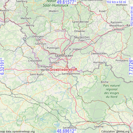
Grosbliederstroff GPS coordinates[2]
49° 9' 29.088" North, 7° 1' 26.868" East
| Map corner | latitude | longitude |
|---|---|---|
| Upper-left | 49.61577°, | 6.32101° |
| Center: | 49.15808°, | 7.02413° |
| Lower-right: | 48.69612°, | 7.72726° |
| Map W x H: | 102.3×102.3 km | = 63.6×63.6mi |
| max Lat: | 51.07786° ⇑16.5% North |
| Grosbliederstroff: | 49.15808° |
| min Lat: | ⇓83.5% South 41.3874° |
| min Long | Grosbliederstro | max Long |
| -5.08615° | 7.02413° | 9.52242° |
| W 95%⇐ | ⇒5% E |
Elevation
Elevation of Grosbliederstroff is 215 m = 705 ft, and this is 21.3 m = 70 ft above average elevation for this country.
| Max E: |
2333 m = 7654 ft | 30.8% |
| Grosbliederstroff | 215 m 705 ft | |
| Avg. | 193.7 m = 635 ft | |
Min E: |
-1 m = -3 ft | 69.2% |
See also: France elevation on elevation.city.
Geographical zone
Grosbliederstroff is located in North temperate zone (between Tropic of Cancer and the Arctic Circle). Distance of this North polar circle is 1935.3 km =1202.5 mi to North.| Distance of | km | miles | from Grosbliederstroff |
|---|---|---|---|
| North Pole | 4541.2 | 2821.8 | to North |
| Arctic Circle | 1935.3 | 1202.5 | to North |
| Tropic Cancer | 2859.9 | 1777.1 | to South |
| Equator | 5465.9 | 3396.4 | to South |


Nearby cities:
15 places around Grosbliederstroff: (largest is in red/bold)
• Alsting
3.5 km =2.2 mi,  318°
318°
• Behren-lès-Forbach
6.3 km =3.9 mi,  281°
281°
• Blies-Guersviller
4.4 km =2.7 mi,  104°
104°
• Bousbach
5.5 km =3.4 mi,  259°
259°
• Etzling
5.3 km =3.3 mi,  296°
296°
• Hundling
6.4 km =4 mi,  210°
210°
• Ippling
6 km =3.7 mi,  193°
193°
• Kerbach
4.4 km =2.7 mi, 282°
• Lixing-lès-Rouhling
2.3 km =1.4 mi, 257°
• Metzing
7.6 km =4.7 mi,  219°
219°
• Nousseviller-Saint-Nabor
5.7 km =3.5 mi, 223°
• Rouhling
2.6 km =1.6 mi, 213°
• Sarreguemines
6.2 km =3.9 mi,  149°
149°
• Spicheren
5.7 km =3.5 mi,  312°
312°
• Tenteling
7.3 km =4.5 mi,  240°
240°
Sources, notices
• [Note1] Compared only with cities in France existing in our database
• [Src1] Map data: © OpenStreetMap contributors (CC-BY-SA)
• [Src2] Other city data from geonames.org with taken over terms of usage.
• [Src3] Geographical zone / Annual Mean Temperature by Robert A. Rohde @ Wikipedia
