Spicheren geodata
Spicheren (Grand Est) is a populated place; located in France in Europe/Paris (GMT+2) time zone. With population of 3,393 people, there are 2870 cities with bigger population in this country. Compared to other cities in France, 84.1% of cities are located further ↓South; 94.6% of cities are located further ←West and 81.8% of cities have lower elevation than Spicheren. Note1
Administrative division(s):
- Level 1: Grand Est
- Level 2: Moselle
- Level 3: Arrondissement de Forbach-Boulay-Moselle
- Level 4: Spicheren


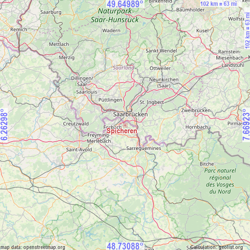
Spicheren GPS coordinates[2]
49° 11' 33.072" North, 6° 57' 57.996" East
| Map corner | latitude | longitude |
|---|---|---|
| Upper-left | 49.64989°, | 6.26298° |
| Center: | 49.19252°, | 6.96611° |
| Lower-right: | 48.73088°, | 7.66923° |
| Map W x H: | 102.2×102.2 km | = 63.5×63.5mi |
| max Lat: | 51.07786° ⇑15.9% North |
| Spicheren: | 49.19252° |
| min Lat: | ⇓84.1% South 41.3874° |
| min Long | Spicheren | max Long |
| -5.08615° | 6.96611° | 9.52242° |
| W 94.6%⇐ | ⇒5.4% E |
Elevation
Elevation of Spicheren is 309 m = 1014 ft, and this is 115.3 m = 378 ft above average elevation for this country.
| Max E: |
2333 m = 7654 ft | 18.2% |
| Spicheren | 309 m 1014 ft | |
| Avg. | 193.7 m = 635 ft | |
Min E: |
-1 m = -3 ft | 81.8% |
See also: France elevation on elevation.city.
Geographical zone
Spicheren is located in North temperate zone (between Tropic of Cancer and the Arctic Circle). Distance of this North polar circle is 1931.5 km =1200.2 mi to North.| Distance of | km | miles | from Spicheren |
|---|---|---|---|
| North Pole | 4537.4 | 2819.4 | to North |
| Arctic Circle | 1931.5 | 1200.2 | to North |
| Tropic Cancer | 2863.8 | 1779.5 | to South |
| Equator | 5469.7 | 3398.7 | to South |


Nearby cities:
15 places around Spicheren: (largest is in red/bold)
• Alsting
2.3 km =1.4 mi,  121°
121°
• Behren-lès-Forbach
3.2 km =2 mi,  217°
217°
• Bousbach
4.9 km =3 mi,  193°
193°
• Etzling
1.6 km =1 mi,  200°
200°
• Folkling
7.2 km =4.5 mi,  226°
226°
• Forbach
5.4 km =3.4 mi,  265°
265°
• Grosbliederstroff
5.7 km =3.5 mi,  132°
132°
• Kerbach
2.9 km =1.8 mi,  180°
180°
• Lixing-lès-Rouhling
4.8 km =3 mi,  155°
155°
• Morsbach
7.4 km =4.6 mi,  248°
248°
• Rouhling
6.6 km =4.1 mi,  154°
154°
• Schœneck
4.5 km =2.8 mi,  306°
306°
• Stiring-Wendel
2.7 km =1.7 mi,  292°
292°
• Tenteling
7.7 km =4.8 mi, 195°
• Œting
4.3 km =2.7 mi,  239°
239°
Sources, notices
• [Note1] Compared only with cities in France existing in our database
• [Src1] Map data: © OpenStreetMap contributors (CC-BY-SA)
• [Src2] Other city data from geonames.org with taken over terms of usage.
• [Src3] Geographical zone / Annual Mean Temperature by Robert A. Rohde @ Wikipedia
