Sannerville geodata
Sannerville (Normandy) is a populated place; located in France in Europe/Paris (GMT+2) time zone. With population of 1,540 people, there are 6052 cities with bigger population in this country. Compared to other cities in France, 83.9% of cities are located further ↓South; 79.9% of cities are located further →East and 94.7% of cities have higher elevation than Sannerville. Note1
Administrative division(s):
- Level 1: Normandy
- Level 2: Calvados
- Level 3: Arrondissement de Caen
- Level 4: Saline


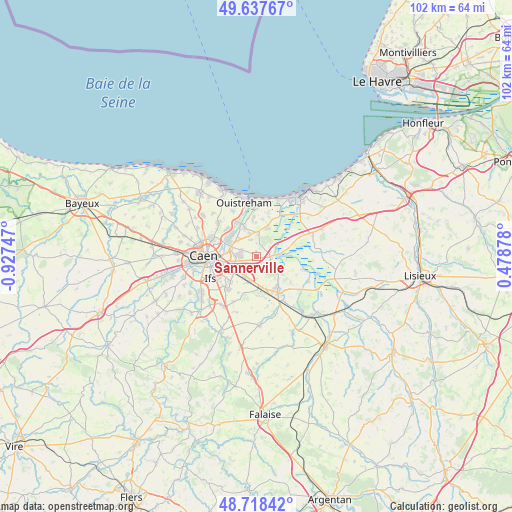
Sannerville GPS coordinates[2]
49° 10' 48.648" North, 0° 13' 27.624" West
| Map corner | latitude | longitude |
|---|---|---|
| Upper-left | 49.63767°, | -0.92747° |
| Center: | 49.18018°, | -0.22434° |
| Lower-right: | 48.71842°, | 0.47878° |
| Map W x H: | 102.2×102.2 km | = 63.5×63.5mi |
| max Lat: | 51.07786° ⇑16.1% North |
| Sannerville: | 49.18018° |
| min Lat: | ⇓83.9% South 41.3874° |
| min Long | Sannerville | max Long |
| -5.08615° | -0.22434° | 9.52242° |
| W 20.1%⇐ | ⇒79.9% E |
Elevation
Elevation of Sannerville is 18 m = 59 ft, and this is 175.7 m = 576 ft below average elevation for this country.
| Max E: |
2333 m = 7654 ft | 94.7% |
| Avg. | 193.7 m = 635 ft | |
| Sannerville | 18 m = 59 ft | |
Min E: |
-1 m = -3 ft | 5.3% |
See also: France elevation on elevation.city.
Geographical zone
Sannerville is located in North temperate zone (between Tropic of Cancer and the Arctic Circle). Distance of this North polar circle is 1932.9 km =1201 mi to North.| Distance of | km | miles | from Sannerville |
|---|---|---|---|
| North Pole | 4538.7 | 2820.2 | to North |
| Arctic Circle | 1932.9 | 1201 | to North |
| Tropic Cancer | 2862.4 | 1778.6 | to South |
| Equator | 5468.3 | 3397.8 | to South |


Nearby cities:
15 places around Sannerville: (largest is in red/bold)
• Bavent
6.2 km =3.9 mi,  26°
26°
• Bellengreville
6.3 km =3.9 mi,  170°
170°
• Bréville-les-Monts
5.9 km =3.7 mi,  353°
353°
• Cagny
4.5 km =2.8 mi,  211°
211°
• Colombelles
5.9 km =3.7 mi,  297°
297°
• Cuverville
3.1 km =1.9 mi,  290°
290°
• Démouville
3.3 km =2.1 mi,  269°
269°
• Escoville
3.5 km =2.2 mi,  341°
341°
• Giberville
4.3 km =2.7 mi, 272°
• Grentheville
5.8 km =3.6 mi,  231°
231°
• Hérouville-Saint-Clair
6.9 km =4.3 mi, 299°
• Hérouvillette
4.8 km =3 mi, 343°
• Ranville
6.1 km =3.8 mi, 337°
• Troarn
3.1 km =1.9 mi,  93°
93°
• Vimont
6.7 km =4.2 mi,  164°
164°
Sources, notices
• [Note1] Compared only with cities in France existing in our database
• [Src1] Map data: © OpenStreetMap contributors (CC-BY-SA)
• [Src2] Other city data from geonames.org with taken over terms of usage.
• [Src3] Geographical zone / Annual Mean Temperature by Robert A. Rohde @ Wikipedia
