Grandcamp-Maisy geodata
Grandcamp-Maisy (Normandy) is a populated place; located in France in Europe/Paris (GMT+2) time zone. With population of 1,920 people, there are 4990 cities with bigger population in this country. Compared to other cities in France, 87.6% of cities are located further ↓South; 88.5% of cities are located further →East and 93.9% of cities have higher elevation than Grandcamp-Maisy. Note1
Administrative division(s):
- Level 1: Normandy
- Level 2: Calvados
- Level 3: Arrondissement de Bayeux
- Level 4: Grandcamp-Maisy


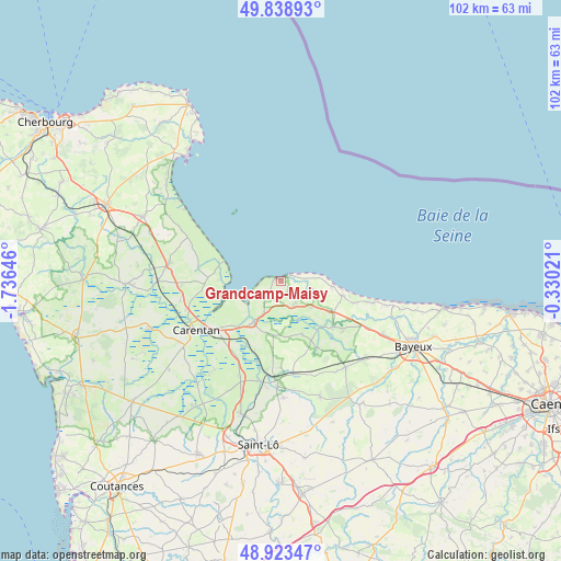
Grandcamp-Maisy GPS coordinates[2]
49° 22' 59.988" North, 1° 1' 59.988" West
| Map corner | latitude | longitude |
|---|---|---|
| Upper-left | 49.83893°, | -1.73646° |
| Center: | 49.38333°, | -1.03333° |
| Lower-right: | 48.92347°, | -0.33021° |
| Map W x H: | 101.8×101.8 km | = 63.3×63.3mi |
| max Lat: | 51.07786° ⇑12.4% North |
| Grandcamp-Maisy: | 49.38333° |
| min Lat: | ⇓87.6% South 41.3874° |
| min Long | Grandcamp-Maisy | max Long |
| -5.08615° | -1.03333° | 9.52242° |
| W 11.5%⇐ | ⇒88.5% E |
Elevation
Elevation of Grandcamp-Maisy is 20 m = 66 ft, and this is 173.7 m = 570 ft below average elevation for this country.
| Max E: |
2333 m = 7654 ft | 93.9% |
| Avg. | 193.7 m = 635 ft | |
| Grandcamp-Maisy | 20 m = 66 ft | |
Min E: |
-1 m = -3 ft | 6.1% |
See also: France elevation on elevation.city.
Geographical zone
Grandcamp-Maisy is located in North temperate zone (between Tropic of Cancer and the Arctic Circle). Distance of this North polar circle is 1910.3 km =1187 mi to North.| Distance of | km | miles | from Grandcamp-Maisy |
|---|---|---|---|
| North Pole | 4516.2 | 2806.2 | to North |
| Arctic Circle | 1910.3 | 1187 | to North |
| Tropic Cancer | 2885 | 1792.7 | to South |
| Equator | 5490.9 | 3411.9 | to South |


Nearby cities:
15 places around Grandcamp-Maisy: (largest is in red/bold)
• Carentan
17.9 km =11.1 mi,  240°
240°
• Graignes-Mesnil-Angot
19.1 km =11.9 mi,  219°
219°
• Isigny-sur-Mer
9.1 km =5.7 mi,  214°
214°
• La Cambe
4.9 km =3 mi,  155°
155°
• Le Molay-Littry
19.5 km =12.1 mi,  143°
143°
• Montmartin-en-Graignes
14.6 km =9.1 mi, 214°
• Moon-sur-Elle
19.7 km =12.2 mi,  183°
183°
• Osmanville
6.9 km =4.3 mi, 209°
• Port-en-Bessin-Huppain
20.6 km =12.8 mi,  102°
102°
• Saint-Fromond
18.5 km =11.5 mi,  192°
192°
• Saint-Hilaire-Petitville
16.2 km =10.1 mi, 236°
• Saint-Jean-de-Daye
18.8 km =11.7 mi,  203°
203°
• Sainte-Marie-du-Mont
13.9 km =8.6 mi,  267°
267°
• Tour-en-Bessin
20.8 km =12.9 mi,  117°
117°
• Trévières
12.5 km =7.8 mi,  131°
131°
Sources, notices
• [Note1] Compared only with cities in France existing in our database
• [Src1] Map data: © OpenStreetMap contributors (CC-BY-SA)
• [Src2] Other city data from geonames.org with taken over terms of usage.
• [Src3] Geographical zone / Annual Mean Temperature by Robert A. Rohde @ Wikipedia
