Graçay geodata
Graçay (Centre) is a populated place; located in France in Europe/Paris (GMT+2) time zone. With population of 1,556 people, there are 5990 cities with bigger population in this country. Compared to other cities in France, 53.7% of cities are located further ↑North; 58.9% of cities are located further →East and 58.3% of cities have higher elevation than Graçay. Note1
Administrative division(s):
- Level 1: Centre
- Level 2: Cher
- Level 3: Arrondissement de Vierzon
- Level 4: Graçay


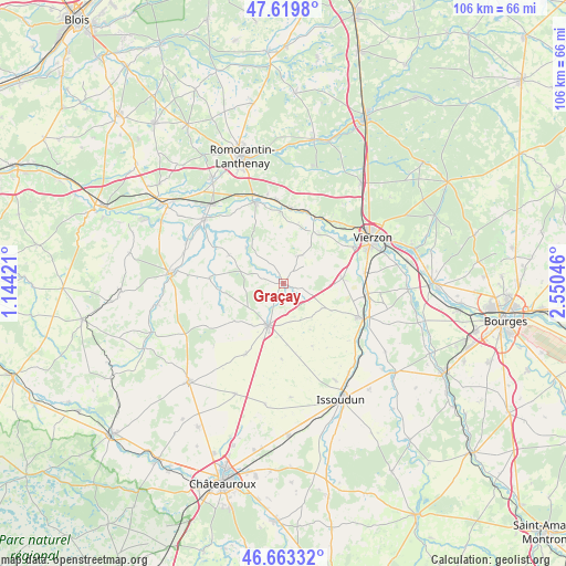
Graçay GPS coordinates[2]
47° 8' 37.356" North, 1° 50' 50.388" East
| Map corner | latitude | longitude |
|---|---|---|
| Upper-left | 47.6198°, | 1.14421° |
| Center: | 47.14371°, | 1.84733° |
| Lower-right: | 46.66332°, | 2.55046° |
| Map W x H: | 106.4×106.3 km | = 66.1×66.1mi |
| max Lat: | 51.07786° ⇑53.7% North |
| Graçay: | 47.14371° |
| min Lat: | ⇓46.3% South 41.3874° |
| min Long | Graçay | max Long |
| -5.08615° | 1.84733° | 9.52242° |
| W 41.1%⇐ | ⇒58.9% E |
Elevation
Elevation of Graçay is 107 m = 351 ft, and this is 86.7 m = 284 ft below average elevation for this country.
| Max E: |
2333 m = 7654 ft | 58.3% |
| Avg. | 193.7 m = 635 ft | |
| Graçay | 107 m = 351 ft | |
Min E: |
-1 m = -3 ft | 41.7% |
See also: France elevation on elevation.city.
Geographical zone
Graçay is located in North temperate zone (between Tropic of Cancer and the Arctic Circle). Distance of this North polar circle is 2159.3 km =1341.7 mi to North.| Distance of | km | miles | from Graçay |
|---|---|---|---|
| North Pole | 4765.2 | 2961 | to North |
| Arctic Circle | 2159.3 | 1341.7 | to North |
| Tropic Cancer | 2636 | 1637.9 | to South |
| Equator | 5241.9 | 3257.2 | to South |


Nearby cities:
15 places around Graçay: (largest is in red/bold)
• Châtres-sur-Cher
14.2 km =8.8 mi,  18°
18°
• Genouilly
6 km =3.7 mi,  29°
29°
• Langon
15.7 km =9.8 mi,  354°
354°
• Lury-sur-Arnon
16 km =9.9 mi,  96°
96°
• Massay
11.1 km =6.9 mi,  84°
84°
• Mennetou-sur-Cher
14 km =8.7 mi,  5°
5°
• Méreau
15.5 km =9.6 mi, 82°
• Méry-sur-Cher
15.6 km =9.7 mi,  43°
43°
• Poulaines
14 km =8.7 mi,  273°
273°
• Reuilly
16.2 km =10.1 mi,  113°
113°
• Saint-Georges-sur-la-Prée
11.4 km =7.1 mi, 36°
• Saint-Hilaire-de-Court
14.7 km =9.1 mi,  62°
62°
• Saint-Julien-sur-Cher
16.4 km =10.2 mi,  340°
340°
• Thénioux
14.2 km =8.8 mi, 28°
• Vatan
8.2 km =5.1 mi,  200°
200°
Sources, notices
• [Note1] Compared only with cities in France existing in our database
• [Src1] Map data: © OpenStreetMap contributors (CC-BY-SA)
• [Src2] Other city data from geonames.org with taken over terms of usage.
• [Src3] Geographical zone / Annual Mean Temperature by Robert A. Rohde @ Wikipedia
